Feeds:
Posts
Comments

Archive for the ‘Roads’ Category

How Far West? Plaza, Beaver Creek, Yukon Territory

On this date in 1942, US Army engineering crews working east from Delta Junction, Alaska and west from Whitehorse, Yukon met up near Beaver Creek, Yukon, completing the Alaska Highway.  For the first time, Alaska was accessible from the Lower 48 by road.  This was a remarkable achievement, especially since it was done in only a few months; construction had begun in March and accelerated in June when the Japanese invaded the Aleutian Islands, making the need for a military route to Alaska seem more pressing.  Also noteworthy about the construction effort was that about a third of the soldiers who worked on the project were black, and their impressive accomplishments apparently played a role in the total integration of the military a few years later.

Two years after the highway was completed, while it was still under US Army control, Frederick Johnson of the Peabody Foundation (now the Peabody Museum of Archaeology at Phillips Andover) conducted an archaeological survey along the route as part of a multidisciplinary expedition that had begun the year before with biological and geological studies.  Johnson published a short article in 1946 describing the survey and illustrating some of the artifacts found.  The main importance of this (apparently largely forgotten) article was just to preliminarily describe the archaeology of a large region that, because it had been so difficult to get to before the construction of the highway, was almost completely unknown.  Johnson says as much in the article, while also noting the theoretical importance of gaining an understanding of this region because of its potential role in the peopling of the New World as a migration corridor.  He doesn’t press the latter point, however, and it’s pretty clear that the artifacts he describes are much too recent to have had anything to do with the initial migrations into North America (although there’s no way he could have known this at the time and he doesn’t say anything about it).

White River, Yukon Territory

The presence of geologists in the group was useful for Johnson’s purposes, as it meant that the stratigraphy of the sites he excavated could be evaluated with an expert eye.  Most or all of the artifacts from the sites he discusses in detail, and perhaps of all the sites he found, came from what appeared to be a single layer of reddish-brown soil under a layer of volcanic ash over five inches thick in some places but much thinner in others and apparently absent entirely in some.  This ash is presumably the so-called White River Ash from the eruption(s) of Mt. Churchill, which is in this general area; these eruptions may have been pretty important in the prehistory of this region and beyond.  The artifacts therefore predate the eruption(s), but not necessarily by very long.

The artifacts themselves, all of stone and almost all chipped rather than ground, consist of projectile points, scrapers, gravers, and a variety of miscellaneous forms.  Johnson notes that the assemblages from all the excavated sites are quite similar, which is noteworthy because the area covered was so large.  This implies they probably date to about the same period (as does the similar geology of the strata in which they were found) and may have been made by people from the same cultural tradition.  The sites themselves all appear to represent the same kind of occupation, which Johnson terms a “workshop” where stone tools were made or repaired.  Only one site had a firepit, and none had anything suggesting the presence of structures.  Beyond that there isn’t much Johnson can say, since the state of knowledge of subarctic prehistory was so rudimentary at the time and the area he was discussing had essentially no prior information at all.

Kluane Lake, Yukon Territory

As it happens, the part of the Alaska Highway I drove on my way up to Anchorage is near some of the sites Johnson mentions, many of which are in the Kluane Lake area of the southwest Yukon.  It was interesting to see placenames I recognized in this article.  I’ve been reading quite a bit about Alaska archaeology recently, and it’s really quite fascinating.  I’m not sure quite where Johnson’s findings fit into the overall picture, since his article seems to be virtually forgotten by now and recent work basically never cites it.  His pictures of artifacts are probably good enough to tell where they would fall in currently understood culture sequences, however, and I have an idea of where that might be but I’ll have to look into it a bit more before discussing it further.  I’m still not sure if this blog will be the best venue for discussing Alaska stuff, but it’s what I’ve got for now and I figured I should mark the occasion of the highway’s anniversary by talking a bit about its much deeper past.
ResearchBlogging.org
Johnson, F. (1946). An Archaeological Survey along the Alaska Highway, 1944 American Antiquity, 11 (3) DOI: 10.2307/275560

Read Full Post »

North Road to Chaco

In comments to the previous post, paddyo’ links to this very good article on the fraught issue of paving the road to Chaco.  The article notes a recent development and explains why it isn’t going forward any time soon:

Chaco Culture officials struck a tentative deal with the county and the Navajo Nation, which owns the last four miles of the road closest to Chaco Canyon, that would have allowed the park to maintain to its standards eight miles of the road outside park boundaries.

But when NPS regional officials met with the Navajo Nation and the county in May, that idea was tossed out.

“We would have had to seek special legislation to do that,” said NPS Denver regional spokesman Rick Frost, adding that for the park to maintain a road outside its boundaries would set a precedent for the entire National Park System.

“Yellowstone plows a stretch of road called the Beartooth Highway at a significant cost to the park,” he said. “We didn’t want to continue that at Chaco and send a signal that we’re willing to do that in a place where it isn’t already taking place.”

I had heard about this idea, and it makes a lot of sense.  I had also heard that it wasn’t going to happen, but I hadn’t realized what the specific roadblock (so to speak) was.  The reason this makes sense is that one of the issues with the road thing is that the county doesn’t do a very good job of maintaining it, especially for the last few miles heading into the park.  They have claimed that this is because that part of the road is on Navajo land and the county isn’t responsible for maintaining it, which sounds dubious to me; it still has a county road number rather than a Navajo one.

Be that as it may, however, the problem is that the last part of the road that visitors encounter before reaching the park is often the roughest part, so they’re often more upset about it on arriving at the visitor center than they would be if they had encountered a full thirteen miles of a consistent quality equivalent to the average quality of the actual road.  The park would have a strong incentive to maintain that part of the road well if it managed to get the authority to do it.  The actual grading, although it would certainly add a certain amount of additional operating costs to the park’s maintenance budget, would be easy and the park could easily manage it with existing equipment and manpower, whereas paving the whole road would necessitate a huge increase in staffing and a whole host of changes in management practices that would be much more expensive.  I can see why the NPS doesn’t want to set a precedent for maintaining roads outside of parks, but this seems like a special case (there area vanishingly few other park units that are not accessible by paved roads, which is one of the reasons people cite for paving this one), plus the precedent really already seems to have been set by the Yellowstone case.

In the long run, I think the road probably will eventually be paved.  The reason we’ve been hearing so much about this in the past few years, in addition to the big push for it by the San Juan County Commission (the reasons for which no one seems to quite understand), is that many of the local Navajos, especially younger people, are now in favor of paving.  For many years the Navajos were generally opposed to paving the road and to anything else that would lead to more tourists visiting the park, but now that paved roads have become pretty common in the Navajo country the younger generation is more willing to accept increased visitation by outsiders in exchange for better mobility for themselves.  I’m pretty sure that’s not what’s driving the Commission, which is dominated by white guys from Farmington and has not historically been very responsive to the concerns of the Navajos (although it does seem to now have one Navajo member).  In any case, I imagine local support for paving will only increase in the future, and eventually the Friends of Chaco will no longer be able to hold it back.

Cattleguard on North Road into Chaco

Read Full Post »

Wheels at Chaco Museum from Ore Cart Used to Haul Fill from Pueblo Bonito

I’m back at Chaco and giving tours again, so I’m once again being exposed to visitors’ common questions and preconceptions in a way I haven’t been in a long time.  One thing that seems to surprise a lot of visitors is the fact that the Chacoans apparently had no knowledge of the wheel, or if they did have such knowledge they didn’t apply it to transport any of the many things they brought into the canyon from distant sources.  (People are also sometimes surprised to learn that they didn’t have draft animals either, which I find a bit surprising myself since I tend to think of that as common knowledge.)

I think it’s actually not difficult to see why the Chacoans wouldn’t have seen any use for the wheel even if they somehow knew about it, and the lack of draft animals is the key to understanding why.  (This is admittedly a bit speculative on my part, but I think it works.)  Without big, strong animals to pull wheeled vehicles, any efficiency gains from them in terms of human labor would be decidedly non-obvious.  The only type of wheeled vehicle that would really be effective using only human labor would be the wheelbarrow, and while this may provide some efficiency gains over carrying goods by hand I don’t think they would have been clear enough to compensate for the increased effort involved in building the thing, especially given the often rough and broken terrain of the Southwest.  Even the Chacoan roads, which may or may not have actually been intended for use in transporting goods but certainly could have been so used once they were built, were actually not as level and easy as people often assume, although they were more level than the surrounding terrain.  Most of the effort put into the roads went into clearing the surface and defining the curbs, but grading of the cleared ground surface was typically not done and the road beds follow the underlying terrain for the most part.  This was fine for foot traffic, and definitely an improvement over the uncleared surrounding terrain, but it wouldn’t have been particularly suitable for wheeled vehicles.  Furthermore, the vaunted straightness of the roads would actually have made them even less suitable for wheeled vehicles or draft animals, given the common practice of handling steep cliffs in the path of the road with stairways.  Good luck getting a cart up or down one of those!

Jackson Stairway

The lack of draft animals and the unevenness of the terrain have also been posited as reasons for the lack of wheeled vehicles throughout the Americas.  While the terrain would not have been an impediment everywhere, such as in the Yucatan where the terrain is generally flat and the roads built by the Maya were much more elaborate and level than anything seen around Chaco, in highland areas like Central Mexico and lowland areas covered by dense vegetation such as those along the Gulf Coast of Mexico the maneuverability of a person on foot would likely have been far more important to efficient transportation than any increase in efficiency resulting from wheeled vehicles in the absence of animals to pull them.  Gordon Ekholm of the American Museum of Natural History, whom we last saw discovering atlatl finger loops, discussed many of these issues in an interesting article from 1946 about the wheeled toys found in various parts of Mexico, which demonstrate that at least the Mesoamericans were in fact aware of the wheel even though they didn’t use it for any practical purpose.  These clay toys, in the form of animals with wheels in place of feet, had been found in widely scattered parts of Central and Northeast Mexico, from Oaxaca to Veracruz, and while the axles connecting the wheels to the feet were apparently made of a perishable material like wood and did not survive, the fact that one example was found in situ with the wheels in the proper position led Ekholm to conclude that they definitely were originally wheeled.  Robert Lister (a very prominent figure in the history of Chacoan archaeology who also did some work in Mesoamerica) followed up on Ekholm’s article shortly afterward, noting the apparent presence of similar wheeled toys in West Mexico and referring to the discovery of copper examples in Panama as well.

Effigy Vessels at Chaco Museum

Ekholm’s article provides a solid discussion of the implication of these toys for Mesoamerican technology and general anthropological understanding of technological development.  He discusses the lack of draft animals and the difficult terrain, but ultimately concludes that the main factor preventing more widespread use of the wheel was likely a cultural and technological conservatism that privileged the old way of doing things, which in this case meant carrying goods on people’s backs, over an untried new invention like the wheel.  He attributes the origin of the idea of wheeled toys to pure invention, probably stemming from experimentation with the round spindle whorls that are very common Mesoamerican artifacts.  It’s not clear just how far this idea spread, and to my knowledge there is no evidence that anyone in the Southwest was aware of it, although some of the ceramic animal effigies found at Chaco and elsewhere do bear some resemblance to the Mesoamerican toys.  Ekholm makes a convincing case that despite the ingenious nature of these toys, without suitable social and ecological conditions for the wider adoption of the technology it remained more of a curiosity than anything else.

Basically, without draft animals, the idea of making a big vehicle like a cart which could carry a heavy load more efficiently than a person could would be unlikely to have occurred to anyone, because such a cart would still have to be pulled by people.  Or, in other words, if you have a cart but not a horse, you are, well, putting the cart before the horse.  And who would do a thing like that?
ResearchBlogging.org
Ekholm, G. (1946). Wheeled Toys in Mexico American Antiquity, 11 (4) DOI: 10.2307/275722

Lister, R. (1947). Additional Evidence of Wheeled Toys in Mexico American Antiquity, 12 (3) DOI: 10.2307/275708

Read Full Post »

Sign at Turnoff from Navajo Route 16, Inscription House, Arizona

Earlier I discussed an article in the Navajo Times by Cindy Yurth about the many difficulties standing in the way of paving roads on the Navajo Reservation.  She has another article elaborating on one of the problems, namely problems within the agencies of the Navajo government that can stand in the way of getting anything done.  This is a constant problem in the complicated and impenetrable bureaucracy that is the Tribe.  This particular article focuses on allegations by one Navajo archaeologist in the Historic Preservation Department that her Anglo supervisor made things difficult for her in a variety of ways that ended up keeping roads projects from going forward.  The allegations are serious, culminating in physical intimidation and assault charges against the supervisor.  As always with this sort of thing, it’s hard to tell who to believe and what was really going on with all the conflicting accounts by different individuals involved, but Yurth does a good job of presenting the different perspectives.  One important thing to keep in mind when reading the article is that there are two separate departments within the Navajo Nation Division of Natural Resources that handle archaeology: Historic Preservation, which handles a lot of different things (including the Chaco Sites Protection Program, which is where John Stein and Taft Blackhorse do their work) but in the context of infrastructure projects serves as a regulatory agency, and the Archaeology Department, which does contract archaeology on large projects and functions like a commercial cultural resources management firm.  The two have a complicated history, and in general do not get along.  Although both are part of the tribal government, the relationship between the two on specific projects is contractual and subject to all the usual tensions and conflicts inherent in compliance situations.  Yurth’s article contains a lot more information on the specifics, but it’s important to have this background information to understand it.  Overall the article, like the previous one, is informative and definitely worth reading.

Road to Navajo National Monument from Shonto, Arizona

Read Full Post »

Poorly Drained Dirt Road near Bisti, New Mexico

One of the most frequent questions visitors to Chaco ask is why the road leading there hasn’t been paved.  That particular road, largely because it leads to Chaco, has a particularly thorny set of issues surrounding the idea of paving, which I’ve discussed before, but one thing I would often mention in dealing with these questions is the fact that paved roads are fairly rare throughout the Four Corners area.  Most roads are dirt, and there are a lot of them.  So it’s not really surprising that the road to Chaco would be dirt, since that’s sort of the default state for roads in the Navajo country.  This would often be surprising to visitors from other parts of the country, where dirt roads are rare to nonexistent.  To them paved roads are the default, and the lack of paving on a given road is odd and demands an explanation.

Informal Two-Track Road at Navajo Indian Irrigation Project, New Mexico

What all this doesn’t address, however, is why so few roads in the area are paved.  Especially since the Navajo country is so large and sparsely populated that for practical purposes driving is the only way to get places, it does seem odd at first glance that there isn’t more effort put into getting roads paved.  As Cindy Yurth points out in a fantastic article in the Navajo Times, however, it’s not that easy to pave a road, especially on the Navajo Reservation.  Some of the issues she mentions don’t really apply at Chaco, which is off the Reservation, but many of the others do, along with some additional complications, most of which have to do with the bewildering variety of governments and agencies that have a say in decisions around Chaco.  The issues of maintenance and the desire of many local residents for roads to remain unpaved, however, apply equally on and off the Reservation.  Anyway, it’s a great article, and I highly recommend it to anyone interested in this issue.

"Street Closed" Sign at Bisti Wilderness Area, New Mexico

Read Full Post »

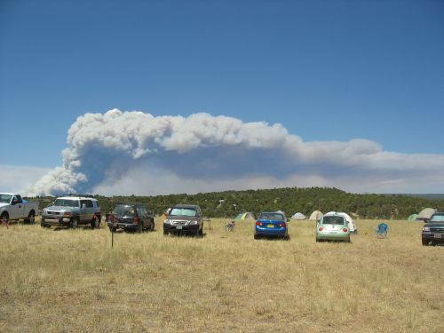
Forest Fire from McPhee Campground, Site of 2009 Pecos Conference

Forest Fire from McPhee Campground, Site of 2009 Pecos Conference

Today was the second (and final) day of the 2009 Pecos Conference.  Like the first day, it involved many short papers, and there was quite a bit of interesting stuff.  Several of the presenters specifically mentioned Craig Childs’s advice from the night before about how to tell their stories, and it did seem like the average quality of presentation was better in today’s presentations than in yesterday’s.  The morning was mostly taken up with a symposium on heritage preservation, which I only saw part of.  The part I did see was pretty interesting, with reflections on the role of private cultural resource management firms and museums in preserving heritage and disseminating information (the presenters were much less enamored of how CRM does this than of the potential role museums can play).  There were then a series of miscellaneous talks, none of which was about Chaco Canyon specifically, but several of which discussed Chacoan outliers and aspects of the Chaco system.  These included a talk about recent research on the Great North Road, one on the recent work at Chimney Rock, another on the San Juan College field school work on the Bolack Ranch in Farmington, and one on Carhart Ruin, the northernmost known Chacoan outlier.  One speaker giving a talk on an understudied Chacoan community in the Chuska Valley rather pointedly refused to name the community, saying that he felt we were just a little too close to Blanding for his comfort, and that while there was a rather noticeable forest fire visible in that direction, it probably hadn’t taken out Blanding yet.  There were various other interesting papers not as closely related to Chaco as well, including one on the enigmatic towers of the Mesa Verde region pointing out that they occur at sites of all sizes and in all sorts of topographical contexts, making arguments for their function based on a single use improbable.  Overall, it was an interesting conference to attend, and I’m glad I did.

Tower at Mule Canyon, Utah

Tower at Mule Canyon, Utah

Read Full Post »

Roads

Welcome Sign at North Entrance

Welcome Sign at North Entrance

I first visited Chaco Canyon in the summer of 2003.  I had just graduated from high school and would be going off to college in the fall.  My parents decided that visiting Chaco would be a good idea, since I had never been there despite having grown up in New Mexico.  We went out there with a couple who are both old family friends and old Chaco hands; the husband is an archaeologist who worked on the Chaco Project and the wife is an anthropologist who did oral history work in the area around the same time.  We camped in the campground, then spent the next day visiting the sites and hiking up to the Pueblo Bonito overlook on the Pueblo Alto trail.  Our friends showed us around and pointed out things we may not have noticed on our own.  It was a great experience, and I have many fond memories of it.

Pueblo Bonito from Above

Pueblo Bonito from Above

One thing I don’t remember is the road coming in.  This may surprise many readers who have been to Chaco.  For many, perhaps most, of the visitors we get, the road is one of the most memorable parts of the trip.  After the turnoff from US Highway 550 it’s eight miles of pavement, then thirteen miles of heavily washboarded dirt.  Most of our visitors don’t seem to be used to dirt roads at all, and they often enter the Visitor Center shaken, jarred, or even furious.  Some demand to know why the road isn’t paved.  Others, who generally have more experience with dirt roads, ask why it hasn’t been graded recently.  Others ask if there is another way out of the park.  (There is, to the south on NM 57, but it’s even worse.)  Still others are too shocked to say much of anything, but it’s clear that they consider that road a nearly insurmountable obstacle to reaching the park.  As, indeed, it is; Chaco gets many fewer visitors than most comparable parks in the area.  Mesa Verde gets about ten times as many (and it shows).  If the road were paved, visitorship would surely skyrocket, as would the fame of the place.  To many visitors it is hard to fathom why this has not already happened.

Line for Tour Tickets at Far View Visitor Center, Mesa Verde

Line for Tour Tickets at Far View Visitor Center, Mesa Verde

Some other visitors, however, come into the Visitor Center and express their appreciation for the fact that the road still isn’t paved.  These are generally people who have been to the park before, often though not necessarily people who live in the southwest, and they are generally pleasantly surprised to see how little has changed since they last visited.  They understand that the road is the only thing keeping the crowds and the pink cement at bay, and they like that.  The isolation that is one of the most notable things about Chaco is in some ways quite artificial, and it’s mainly the nature and reputation of the road that keeps it that way.

North Entrance to Chaco on County Road 7950

North Entrance to Chaco on County Road 7950

When people ask about the road, I often tell them that there’s talk of paving it, which there is, but that it’s a controversial issue, which it is.  This surprises a lot of people who can’t seem to grasp the idea that anyone would not want the road to be paved.  I often explain the situation as a case of some people wanting change and others not wanting it, and sometimes I go into more detail about the two sides.

Escavada Wash and North Road to Chaco

Escavada Wash and North Road to Chaco

There has been a big push lately by San Juan County, which maintains the road, to pave it; a couple of county commissioners are really pushing for it for reasons that are somewhat obscure.  Unlike in the past, the pro-paving advocates now have many of the local Navajo residents on their side, and the Navajo Nation Department of Transportation is also in favor of paving.  Although the Navajo Nation is not responsible for the road and doesn’t have any formal authority over it, some of the land it crosses is owned by the Navajo Nation, so there is a connection there.  Recently the county got funding for paving and tried to push ahead with it without going through the whole mandated process for doing so, and the groups on the other side of the issue called them on it and noted that they needed to go through the required environmental assessments and such.  As it turned out, those studies ended up using up all of the funding available.  Then the economy collapsed, so it’s unlikely that the road is going to be paved any time soon.

Curve on North Road

Curve on North Road

So who are these groups on the other side?  Well, certainly many of the local Navajos are still opposed to paving and the changes it would bring, but the most vocal opponents are the people who like the park the way it is and have been coming to it for years.  They don’t want the crowds and the restrictions on access that they would force the park to impose, and they don’t see the road as nearly the obstacle that others perceive.  As far as they’re concerned, Chaco is fine the way it is, anyone who really wants to go there can, and there’s no reason to mess with things.

Cattleguard on North Road into Chaco

Cattleguard on North Road

And, indeed, they have a point.  I certainly like the place the way it is and see no reason to change it.  As I mentioned above, the road is not something I remember from my first visit.  Growing up in the southwest, I would travel on so many dirt roads much longer and rougher than this one that it didn’t even register as anything unusual to me.  It’s certainly a pretty good road as dirt roads go, and the washboarding is just the result of the amount of traffic it gets.

South Road to Chaco

South Road to Chaco

I’m not sure I’m totally on board with the paving opponents, though.  While I think the road is fine as is, I don’t see the need to be so vehement in opposing change.  Chaco isn’t perfect, and while I certainly wouldn’t want to work here if it got the kinds of crowds Mesa Verde gets, I think that kind of traffic would force some much-needed changes in the way the park is run that would ultimately protect the resources better.  While it’s nice to be able to wander around the sites without needing to be supervised or on a guided tour, it makes it much too easy for visitors to do damage, whether deliberate or inadvertent, and the way the number of artifacts lying around each site varies inversely with the amount of visitation each one gets speaks to the amount of theft that goes on even given the generally responsible visitors we get.  Clamping down the way Mesa Verde does would be a big shift, but probably ultimately a worthwhile one.
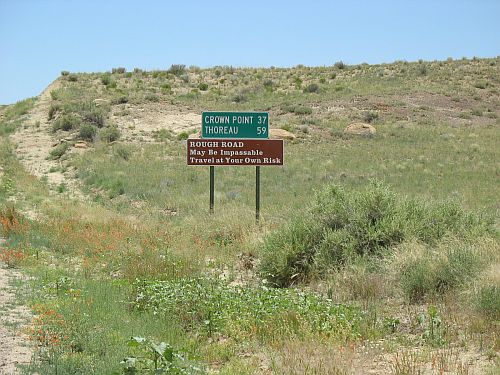
"Rough Road" Sign at South Entrance

"Rough Road" Sign at South Entrance

Not that I see any need to push vehemently for paving either, of course.  Like I said before, I like Chaco fine the way it is and see no reason to change, despite the possible advantages of change that I just noted.  Basically, I see no reason to care strongly one way or the other, so I take a position of studied neutrality and try to explain the situation in as balanced a manner as possible when people ask.  This has the result of shifting visitors from the pro-paving to the anti-paving camps surprisingly often.

"You're Entitled" Sign in Farmington, New Mexico

"You're Entitled" Sign in Farmington, New Mexico

Not always, of course.  There’s a definite sense of entitlement out there among a lot of people, a sense of outrage at the idea that the convenience of the traveling public is not everyone’s highest priority, a sense that National Parks and World Heritage Sites should be as accessible as possible.  It’s a coherent and rational worldview, just not one that meshes well with the way things work at Chaco.  There are actually not that many people who express this attitude strongly, but those who do will not be dissuaded from it, and I don’t try to dissuade them.  In these contexts it becomes more of a live-and-let-live matter, and the most I can do is hear them out, which I do.  It often makes them calm down, but it doesn’t change their opinions.

Cattleguard at North Entrance to Chaco

Cattleguard at North Entrance to Chaco

The irony of all this, of course, is that Chaco is also strongly associated with roads of a very different sort.  The ancient Chacoans built an elaborate system of roads both within and beyond the canyon, traces of which can still be seen today (though generally not from ground level).  While some of these roads were known from the earliest studies of Chaco in the early twentieth century, knowledge of them had been largely forgotten by the 1970s, when they were rediscovered with a vengeance.  The discovery of the extent of the roads, which have been found not only within the canyon and radiating out from it but in the vicinity of many outliers as well, was a crucial part of the reinterpretation of Chaco as a regional system.  The roads have been given a lot of emphasis in many theories about this system.

New Sign at Kin Ya'a, Free of Bullet Holes

Sign at Kin Ya'a Showing Roads

Up until the early 1990s almost everyone who worked on the roads interpreted them as a transportation network used for some practical purpose, perhaps transporting the vast quantities of wood and other materials from the outlying areas to the canyon or, in more ritual-based theories, facilitating pilgrimages to the canyon.  Some theories combine different functions for the roads.  The fact of the existence of the road network was a major piece of evidence for the strongly integrated, centralized system that most archaeologists envisioned Chaco to be, and the presence of roads was even used to define the extent of the system.

Jackson Stairway

Jackson Stairway

There are some problems with these interpretations, however, and by the 1990s some archaeologists began pointing them out.  For one thing, the roads are massively overbuilt for any functional purpose.  They vary in width, but outside of the canyon are typically about 30 feet wide.  They are so wide, and so shallow, that they are usually not visible on the ground and have mostly been identified through aerial photography.  In a society without draft animals or wheeled vehicles, it’s hard to see why a road that wide would be necessary for any practical use.  They are also extraordinarily straight.  Although there are a few examples of road segments that curve, for the most part road segments run on very precise bearings for considerable distance, and when they do change direction they do so with very sharp, angular turns.  They also make little or no allowance for topography: when a road segment comes to a steep slope or sheer cliff, rather than changing the bearing or winding up via switchbacks it generally goes straight up via a ramp or staircase cut into the rock.  This preserves the straightness of the bearing, at the cost of an enormous amount of work.

Ramp View

Ramp View

In addition, while at least two roads (the Great North Road and the South Road) have been determined to run more or less continuously for many miles, most of the roads actually consist of short, discontinuous sections.  In most earlier theories it was assumed that this was just because parts of them had eroded away, and there is surely something to that, but there are also short segments, especially near great houses, that don’t seem to line up with any other segments.

Stairway behind Hungo Pavi

Stairway behind Hungo Pavi

These features of the roads suggest that they are either more or less than practical transportation routes.  Some archaeologists have therefore argued that they served more of a ritual or ceremonial function, perhaps integrating the system in an abstract rather than physical way.  The first to argue this was John Roney in a 1992 paper in which he pointed out the discontinuous nature of the roads and their greater elaboration near great houses.  He argued from this that the roads are actually elements of the great-house landscape rather than long-distance routes, and that their main function may actually have been the integrative effect of community effort in building them.  From a slightly different tack, Michael Marshall has argued that the longer roads may have been oriented toward significant landscape features, such as Kutz Canyon and Hosta Butte, rather than outlying communities, and that they served as grandiose elements of a ritualized landscape.
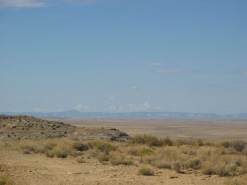
Hosta Butte from New Alto

Hosta Butte from New Alto

In any case, while the morphology of the roads has been fairly well established, debates continue to rage over their function.  One consideration that does not seem to have received much attention in these debates is the widespread presence of road networks in Mesoamerica, which suggests that the roads might be another example of Mesoamerican influence on the Chaco system.  Whatever the roads were, however, they certainly required a lot of effort to build, and while I think their importance to the meaning of the Chaco system has often been overstated, they are definitely a major aspect of it that bears consideration.

Room Forming Base for Stairway at Talus Unit behind Chetro Ketl

Room Forming Base for Stairway at Talus Unit behind Chetro Ketl

Past and present, in the minds of many, Chaco is about roads.  In some respects, it would probably be accurate to say that the ancient roads were better than the modern ones.  While in both contexts roads are not among the things I find most significant or meaningful about Chaco, they are certainly very important, and they will just as certainly provoke strong feelings of all sorts for a long time to come.

Fajada Butte from North Road

Fajada Butte from North Road

Read Full Post »

Chetro Ketl Great Kiva from Above

Chetro Ketl Great Kiva from Above

Shortly before I began working at Chaco I read The Image of the City by Kevin Lynch.  This short book, published in 1960, was one of the foundational texts of the then-emerging field of urban design.  In it Lynch presents a not-very-rigorous methodology for analyzing urban form and a resulting theory dividing a city for analytical purposes into a set of elements: paths, edges, districts, nodes, and landmarks.  These interact in various ways to form cityscapes that either work aesthetically or don’t.  Lynch concludes that while some American cities work better than others, they all have problems, and a properly designed city is imaginable but has not yet been created.  He also notes that in the modern era the proper scale of urban design is not the city in a narrow, traditional sense but the metropolitan area, a social unit on a scale beyond anything yet incorporated into architecture or city planning.  While he concedes that nothing like this is even close to happening in real life, he notes the possibility of using the aesthetic principles he has outlined in this book to form the basis for a system of design principles to be used to make the metropolitan area, a thing unimaginably vast and disturbing by the standards of ordinary human perception, into a comforting and aesthetically pleasing environment.

When I arrived at Chaco and began learning about it in detail, it soon occurred to me that while Lynch’s vision of large-scale design had not been implemented in any modern American city, the principles he outlined were strikingly relevant to the ancient canyon.  Indeed,  it seemed almost trivially easy to take Lynch’s methodology, apply it to the remains of the Chaco system, and conclude that the design of Chaco approximated a realization of Lynch’s ideal city much better than any actually existing modern American city does.  When I first began to conceive the idea of starting this blog, in fact, one of my first ideas for a potential post was to do just that.

South Entrance to Casa Rinconada

South Entrance to Casa Rinconada

As it turned out, I was not the first to come up with this idea, and I realized not long after I started working at Chaco that it had already been done.  The context was an edited volume, arising from a conference, called Anasazi Architecture and American Design.  This conference and the resulting book were intended to bring together archaeologists, historians, architects, planners, and others to discuss and reflect on the connections between past and present.  I bought this book and read it eagerly, because this is a topic of considerable interest to me.

I won’t say it was a disappointment, exactly, because there’s a lot of good stuff in the book, but I would definitely say that it could have done a much better job of what it purports to do.  The most interesting and useful chapters are those by archaeologists, including Michael Marshall’s description and interpretation of the Chacoan road system and David Stuart’s presentation of his evolutionary theory of prehistoric southwestern cultural change.  The chapters by planners and architects, in contrast, are surprisingly superficial and often seem to miss the most important points.  Many seem determined to harness evidence from prehistory to support preordained conclusions about the best ways of designing communities in a modern context; the worst in this regard is Paul Lusk’s chapter on site design, which makes extraordinary efforts to use Anasazi practices as evidence for the superiority of New Urbanism.  Stephen Dent and Barbara Coleman’s chapter applying Lynch’s urban design theories to Chaco falls into this same category.

Northwest Corner of Pueblo del Arroyo

Northwest Corner of Pueblo del Arroyo

It’s not that Dent and Coleman are wrong, exactly.  In fact, they apply Lynch’s theories to Chaco in pretty much the exact same way I was thinking of doing so.  There’s a really striking lack of depth or context, however.  The overall tone of the chapter is one of wonder at the achievements of the Chacoans and hope that we might be able to learn from and emulate them.  This is hardly surprising, since as I mentioned before Chaco clearly shows a coherence of design unmatched by any modern city.  It’s problematic, though, because the implication is that the Chacoans had it right and we should strive to imitate them as much as possible.  They authors don’t really grapple with what I would say is one of the most important thing about Chaco: its impermanence.

Chaco was quite impressive in its day, but in the greater scheme of things its day was quite short.  The Chaco Phenomenon, whatever it was, only lasted for about a hundred years, and it seems to have fallen apart rather suddenly and spectacularly.  All the focus that Dent and Coleman, along with the other planners and architects who contributed to this volume, put on Chaco, the perfection of its planning and architecture, and the importance of emulating it to create sustainable communities ignores the fact that Chaco itself, however sustainable it may have been in theory, was in practice not sustained.  (This attitude is even more problematic when applied to Mesa Verde, as is done in some other chapters.)

Tsin Kletzin from a Distance

Tsin Kletzin from a Distance

The archaeologists get this.  While the planners and architects tend to focus intensely on the well-known sites at Chaco and Mesa Verde, the archaeologists are more familiar with the broad sweep of southwestern prehistory and the way these cultures developed and adapted to changing circumstances.  Probably the most useful chapter in the book is Steve Lekson’s, in which he gives some context and shows that focusing on Chaco and Mesa Verde results in a dangerously skewed perception of what is typical and important about southwestern prehistoric cultures and their legacy.

It’s unfortunate that this book and conference couldn’t have done more to develop an interdisciplinary synthesis of the important lessons to be learned from Chaco and their application to modern problems.  I think such a synthesis is both possible and desirable, but it requires a much more serious effort on the part of modern practitioners to seriously grapple with the confusing and difficult archaeological record and the limited but telling glimpses it gives of past societies, their problems, and the solutions they devised, some of which were clearly more successful than others.  There are useful lessons for modern America to learn from Chaco, but for the most part they aren’t in this book.  Anasazi America, David Stuart’s later development of his ideas, despite some problems of its own, is a much more serious and useful book for these purposes.  I hope there will be others in the future, incorporating the perspectives of modern practitioners as well as archaeologists, but founded on a deep and meaningful understanding of the past.

Northwest Corner of Hungo Pavi

Northwest Corner of Hungo Pavi

Read Full Post »