Feeds:
Posts
Comments

Archive for the ‘Far’ Category

rinconadasolsticewindow

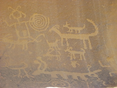
Opening at Casa Rinconada That Channels Sunbeam at Sunrise on Summer Solstice

Today is the summer solstice, so I thought I’d pop back in to do a post about archaeoastronomy, as is my wont. This time it isn’t about the archaeoastronomy of Chaco Canyon per se, but the larger context in which it would have developed, namely that of the civilizations of Mesoamerica to the south.

I’ve mentioned before that I have a tentative theory that part of the impetus for the rise of Chaco as a regional center may have been that its leaders were the first in the Southwest, or at least the northern Southwest, to develop a ritual system based on astronomical observation and alignments, which would have enhanced their ritual authority and consequently their economic and political authority as well. It can be very difficult to date archaeoastronomical phenomena, but it does appear based on my research so far that Chaco does indeed have the earliest datable evidence for astronomical alignments in the northern Southwest, and possibly in the Southwest as a whole. (There is some possible evidence for earlier alignments among the Hohokam of southern Arizona, but it’s somewhat questionable.) This provides some tentative support for the theory.

I don’t think it’s likely that the Chacoan leaders developed their astronomy on their own, though. There is plenty of evidence for contact and communication between them and Mesoamerica, though it isn’t always clear how direct this may have been (as opposed to indirect and mediated through groups in between such as the Hohokam). The much more complex societies of Mesoamerica also had much more elaborate astronomical and calendrical systems than anyone in the Southwest, so they are an obvious source for this as well.

They also presumably developed their knowledge earlier, so as I was thinking about my Chaco theory it occurred to me that it would be good to look into when exactly astronomical alignments and other evidence of this knowledge appear in Mesoamerica and how they spread and changed over time. Basically, the question is whether what is known about the origin and spread of astronomical knowledge in Mesoamerica is consistent with what appears to be true of the origin and spread of similar knowledge further north. Also, it would be helpful to know just how similar the alignments and other phenomena known from Mesoamerica are to those in the Southwest, again to judge the plausibility of a connection.

Luckily for me, an article published last year addressed this exact issue. Written by the Slovenian scholar Ivan Šprajc, it was published in the Journal of Archaeological Research and discusses the temporal and spatial distribution of different building alignments in Mesoamerica. It’s actually a bit odd that this article was published in this journal, which mostly publishes review articles giving a broad overview of recent research on a certain topic in archaeology. Šprajc’s article is in the form of such a review, more or less, but it actually primarily discusses a specific research project done by him and several collaborators, in which they collected very precise and complete data on the alignments of major buildings at many archaeological sites throughout most of the Mesoamerican culture area and analyzed them statistically to come up with general patterns of alignment and see what patterns emerged.

The results were very interesting, especially from an outside perspective. You might expect alignments to the summer and winter solstice sunrises and sunsets to be common, and they were to some extent, but they were by no means the most common. (Alignments to cardinal directions were also present but were even less common.) Much more common, especially in the Maya region, were alignments to certain points on the horizon that do appear to reflect particular sunrises and sunsets, but on different days than the solstices. The specific days cluster in February and October for sunrises and April and August for sunsets. Based on comparisons to ethnohistoric and modern ethnographic accounts of agricultural cycles, Šprajc proposes that these dates marked significant points in the cycle of planting and harvesting cycle, especially for maize, and that marking them would have been part of a very practical system of timekeeping that would also presumably have had ritual importance.

Furthermore, the numbers of days separating many of these dates that pattern together at particular sites tend to reflect multiples of 13 and 20, which are key numbers in the Mesoamerican calendar system, particularly in the 260-day ritual calendar. (Note that 260 is 13 times 20.) Based on the practices of some modern Maya communities that still measure their agricultural cycles this way, it appears that the alignments to mark the key dates would have allowed people to count from those points to figure out the rest of the cycle using these intervals. Since the same dates recur at these intervals in the ritual calendar, which is not calibrated to the solar year, people could have easily used them to keep track of the times for specific activities without worrying about a general calibration.

As a simplified example, if the alignment of a building in a community marked the beginning of the planting season based on the position of the sun, and the community knew that the harvest would come 260 days later, they could take note of the ritual calendar date (number and day-sign) of the beginning day marked by the alignment, the correspondence of which to the solar calendar would vary from year to year, and know that when that date came up again it would be time for harvest. This seems to me like a clever way to deal with the eternal problem of calibrating a solar calendar to seasonal cycles.

Be that as it may, it seems reasonably clear that nothing nearly this elaborate in either calendrical development or architectural alignment was present in the ancient Southwest (though it would be interesting to check some building alignments to see if any of these particular ones show up, which as far as I know no one has done). More interesting to me from my Southwestern perspective is Šprajc’s regional and temporal analysis, which does seem to tentatively provide some support for my Chaco theory.

Šprajc finds, perhaps unsurprisingly, that solstice alignments are the earliest, and that they are particularly characteristic of Preclassic sites in several regions, including Central Mexico, the Olmec region on the Gulf Coast, and the Pacific Coast of Guatemala. What he calls “quarter-day” orientations, which are not strictly to the equinoxes but to the calculated points in between the solstice alignments, are also common in early sites and often associated with solstice alignments. (He is dubious that actual equinox alignments really existed because they are difficult to observe.) In contrast, these alignments are fairly rare in early Maya sites.

The more complex calendrical alignments also appear fairly early, especially in Oaxaca but also in some Olmec sites as well as some in Central Mexico. It appears to be at Teotihuacan in the Early Classic period where two of the widespread calendrical alignments appear together for the first time, accounting for this major city’s well-known layout featuring two slightly different street grids. The subsequent spread of these alignments may be due in part to influence from Teotihuacan throughout Mesoamerica during the Classic period.

Among the areas of apparent Teotihuacan influence in alignment were northern and western Mesoamerica, which are the areas through which influence would presumably have flowed on its way to the Southwest. Šprajc notes, however, that the pattern of alignments shows a lot more diversity in these areas than elsewhere, with solstice and even cardinal alignments retaining substantial influence, and the northern site of Alta Vista may even have a true equinox alignment. From following the references to the more detailed report, it appears that the northern and western sites in the sample are all relatively late, with none earlier than the Early Classic. This is consistent with a spread of at least solstice alignment concepts, and possibly some other ideas, spreading gradually in this direction from the Mesoamerican heartland, eventually reaching Chaco by its rise in the Early Postclassic.

Finally, a word on the moon. Lunar standstill alignments have been identified at some Chacoan sites, especially Chimney Rock, but are controversial due to their general rarity worldwide. I found it intriguing, therefore, that Šprajc does identify some of these in Mesoamerica, but clustered primarily into specific subregions, especially the northeast coast of the Yucatan Peninsula and the Usumacinta drainage at the western edge of the Maya Lowlands. These alignments seem to be to the major lunar standstill and are associated with solstice alignments, implying that perhaps it was the full moons near the solstices that were primarily observed. They also seem to be associated with worship of a particular moon goddess, which helps to distinguish them from alignments to Venus, which are similar and were present in other subareas. This is way on the other end of Mesoamerica from the part most likely to have influenced the Southwest, so direct influence seems unlikely, but it’s interesting to note.

Overall, this article provides very interesting context for understanding Chaco and the role astronomy may have played in its florescence. Happy solstice!


Read Full Post »

bclighthouse

Lighthouse on the Coast of British Columbia

In the previous post, I mentioned that the study of Native California solstice observation that I was discussing found that southern California groups had types of observation resembling those in the Southwest, while northern California groups had observation types more like those of the Northwest Coast. This makes sense in terms of the larger cultural patterns tying these California groups to these other regions in general. However, when I started thinking more about this particular pattern I realized that there was something odd, or at least unfamiliar, about it.

The Southwest is of course very well known for its Native astronomy, both ancient and modern. The same is not true of the Northwest, however. This region is ethnographically very well-studied, and is well known for its cross-culturally unusual pattern of complex hunter-gatherer societies with a variety of elaborate social institutions. Astronomical observations, however, are not among the institutions widely associated with the Northwest. In contrast to the wide-open skies, sunny weather, and distant, varied horizons of the Southwest, the Northwest is a humid, rainy area of dense forests and mountains that come all the way to the sea. This would be a hard place to observe the sun! What’s more, astronomy and calendars are often associated with agriculture and the need to keep track of seasons for planting and harvesting, but the Northwest tribes had no agriculture and instead relied on hunting, gathering, and especially fishing for their subsistence. Did they really observe the sun and keep track of the solstices?

To try to answer this question, I followed the references from the California paper and found that those relating to the Northwest pretty much all came back to one publication, a monograph by Leona Cope published in 1919 entitled Calendars of the Indians North of Mexico. This is a systematic survey of the ethnographic information available at that time about the calendrical systems in this large region. To my knowledge there has never since been a similarly comprehensive study with updated information, which is unfortunate as the data available 100 years ago for many tribes and areas was quite sketchy and incomplete.

Be that as it may, Cope did quite well with the information she had available. She divided the types of calendars into three categories, based on the origin of the names of the months or “moons”:

  • Descriptive Type, by far the most common and found throughout the continent. The months are named descriptively, often after natural seasonal phenomena but sometimes after cultural phenomena such as ceremonies.
  • Numerical Type, the rarest and most restricted in distribution, running discontinuously along the Pacific coast from southern Alaska to northern California. Some or all of the months are numbered rather than named, though very few calendars use numbers exclusively.
  • Astronomical type, the one of most interest for my purposes here. The calendar, while based on lunar months like the other types, is calibrated in some way to one or both of the solstices. Found in three regional clusters: the Southwest (plus southern California), the southern Northwest Coast, and the central and eastern Inuit groups in Arctic Canada and Greenland.

This is a very interesting distribution of solstice observations! Cope attributes the Inuit observation practices to the unusual seasonal conditions of the far north, which is fair enough though it should be noted that not all of the Arctic or Subarctic groups in her study have astronomical calendars. She notes that the Inuit track the sun by indirect observation of shadows cast by rocks, in contrast to the direct observation of the sun used in the Northwest and Southwest (though recent archaeoastronomical work in the Southwest strongly suggests that at least some indirect observation was done there in the past as well).

Cope also has some information on the function of solstice observation among some of the Northwest tribes. She says of the Nuu-chah-nulth of Vancouver Island:

The observation of the solstice is of great economic importance. If one
wishes to be successful in the hunting season, he must perform certain magical rites when the days are getting longer and the moon is waxing.

Again, very interesting! This is quite different from the ideology surrounding sun-watching among Southwest agriculturalists, but it has a clear logic to it that would provide an incentive to undertake the difficult task of making these observations in the Northwest.

Also noteworthy is the distribution of solstice observations within the Northwest. Many of the more “complex” features of Northwest Coast societies are generally considered to reach their highest level of complexity at the northern end of the area, among such groups as the Tlingit, Haida, and Tsimshian of southeast Alaska and adjacent parts of British Columbia. Cope’s data show clearly, however, that the area of astronomical calendars and solstice observation is focused on the southern Northwest Coast, with the most detailed accounts of observations and the ideology behind them associated with the Wakashan-speaking groups on and around Vancouver Island. (Cope does classify the Haida and Tsimshian as part of her Astronomical Type, but only because they include a “between period” in their calendars to rectify the lunar months with the solar year. Her data show no trace of an astronomical calendar among the Tlingit.)

These Wakashan-speaking groups are distinctive in other ways; the Nuu-chah-nulth and related tribes are known for their focus on whaling rather than salmon fishing as the basis of their lifestyle, for example. It’s conceivable that solstice observation was originally a Wakashan trait associated with the ideology mentioned above, which later spread to some but not all neighboring groups but not necessarily with the ideological content intact. That’s largely a speculation on my part, though, and I need to research this more to see if it holds up.

After reading this study and seeing the intriguing evidence for ethnographic astronomical observance in the Northwest, I started reading up on the archaeology of this area to see if there has been any research on potential material correlates. The answer appears to be essentially “no,” in striking contrast to the situation in the Southwest where the ethnographic and archaeological evidence is routinely used in combination to better understand both. One major reason for this is surely the environmental context, which is not nearly as good for preservation of structures as the dry Southwest, except in certain unusual circumstances where sites get completely waterlogged. There’s just not much there to study, in other words, if you’re looking for alignments of buildings to astronomical phenomena.

Rock art, however, which is another frequently studied locus for archaeoastronomy, is common in the Northwest. Petroglyph sites here tend to be on beaches and to be associated with the sea, so they may be less likely to have astronomical associations here than in other areas, but it doesn’t appear that anyone has ever really checked.

More fundamentally, it seems like the archaeology of the Northwest has been so heavily dominated by research on economic issues and attempts to explain the complexity of ethnographic societies that things like astronomy don’t really enter into the literature much at all. There is also likely a bias toward focusing on phenomena that can be easily matched to the richly documented ethnographic cultures.

This bias became clear to me when I saw a passing reference in a review article on the archaeology of British Columbia to undated burial mounds on the South Coast. Burial mounds? In the Northwest? This is another phenomenon often associated with “complex” societies that is not often mentioned in connection with the Northwest Coast, presumably in this case because there is no ethnographic evidence for it having survived into the recent past. Mounds are also often associated in other areas with astronomical observations and alignments, which is why this reference piqued my particular interest.

I followed the reference, which went to a 1947 paper in a local historical journal summarizing a lot of information on these burial mounds, often called “cairns” as they were typically built with large rocks covering a burial in a complex but very regular pattern. Earthen examples are also known, however. The area of the mounds seems to have been focused once again on Vancouver Island, but in this case the focal point seems to have been the area now occupied by the city of Victoria. This area is occupied in modern times by speakers of Salishan rather than Wakashan languages, so there may not be any connection to the astronomical pattern. It is intriguing, however.

The 1947 article focuses largely on the excavations of the mounds in the late nineteenth century by an early settler named James Deans, who reported much of his work in brief letters to a local newspaper though he did write at least one longer unpublished report. Many of them were later excavated in the 1890s by the Jesup North Pacific Expedition, with Deans’s assistance. This expedition was a groundbreaking and highly influential project, with its results including the mound excavations extensively published in reports by the American Museum of Natural History in New York, which at the same time was also sponsoring the Hyde Exploring Expedition excavations far away at Chaco Canyon. The presence of prehistoric mounds in the Northwest Coast was hardly obscure, that is to say. And yet it seems to have been largely forgotten in the modern archaeological literature of this region, or at least rarely seems to rate even a mention in a review article.

Part of this puzzling lack of continued attention to the mounds was likely due to the fact that virtually all of them have since been destroyed by urban and agricultural development, so unlike in other areas known for mounds there’s no longer anything to see. Out of sight, out of mind, as it were. I suspect that the other factors I mentioned above also played a role, however.

While mounds in other areas often have archaeological associations, there is no evidence that I can see that these burial mounds did, though again they have not been studied from this perspective. Another of Deans’s letters to the newspaper provides evidence for a different sort of prehistoric phenomenon which also seems to have disappeared and been forgotten. These are straight, paired stone alignments, of considerable age and consistent orientation to 12 degrees north of east. This is the sort of thing that may indeed have had an astronomical function, although that azimuth is not particularly meaningful as far as I can tell. Sadly, when Deans wrote in 1872 they were already mostly destroyed so there is presumably no way of studying them now.

I don’t really have a point here as I’m continuing to study all this, but it sure is fascinating. You just never know what’s out there.


Read Full Post »

californiasign

California Welcome Sign

Today is the summer solstice, on which I tend to write about archaeoastronomy. This time I’d like to briefly discuss an area with a rich heritage of Native astronomy that seems to get relatively little discussion: California.

California is known in anthropological circles for the astonishing variety of cultural and sociopolitical groups that traditionally inhabited this climatically favorable, highly productive area. Although these groups were all devastated to varying degrees by the influx of Anglo settlers in the nineteenth century, and some were also heavily affected by earlier Spanish colonization starting in the late eighteenth, most of them are fairly well documented ethnographically due to the extensive “salvage ethnography” pioneered by Alfred Kroeber and his students at Berkeley in the early twentieth century. There is therefore a rich base of data in which to look for evidence of Native astronomical observations, and a paper published in 1979 by Travis Hudson, Georgia Lee, and Ken Hedges does just that, in addition to reporting some early archaeoastronomical observations at California archaeological sites. The paper focuses specifically on solstice observations, which tend to be among the most important astronomical practices in many cultures.

The authors’ review of the literature shows that observation of the solstices was widespread in Native California. The vast majority of groups they investigated had some record of solstice observation, and most of those that did not may just not have had it documented. Only two groups were associated with definite statements that they did not observe any solstices, and even these might be due to mistaken information.

The winter solstice was by far the most commonly observed, with relatively few groups also observing the summer solstice and none observing summer but not winter. This ties in to a widespread pattern of keeping a calendar that often began with the winter solstice. A general geographic pattern held that Southern California groups were more likely to observe both solstices, while Northern California groups tended to only observe the winter one. This is in keeping with broader geographic patterns, with Southwestern groups generally observing both solstices but Northwest Coast groups focusing on the winter. There are many other cultural patterns connecting these two parts of California to these adjacent culture areas as well.

In addition to the ethnographic data, the authors report on several observations of potential solstice observation alignments at archaeological sites, mostly those involving rock art. These again showed a general pattern of most often aligning with the winter rather than the summer solstice. In some cases the rock art associated with these observation points contained apparent solar imagery, and in a few cases the authors even suggest that some of the rock art symbols represent the actual horizon line along which the sun was observed. This is a fascinating suggestion that I have not seen made of any other area, so it may be distinctively Californian if it holds up. They include examples of other rock art of similar form that may also be interpreted this way, although it has not been tested for alignments.

All in all, this is a fascinating introduction to the astronomy of a culture area that doesn’t get as much attention in this respect as others like the Southwest and Plains. While this was an early paper in the development of archaeoastronomy and not all of its conclusions may hold up, it is still an excellent starting point. Happy solstice!


Read Full Post »

unavidapetroglyphs

Petroglyphs above Una Vida

I often peruse used bookstores and particularly look at their sections on archaeology, anthropology, history, Native American studies, and other subjects of interest to me. Some bookstores are better than others in these subjects, and my main local one is pretty good. A while back I saw a book there on the subject of Native American rock art that I had not seen before: Painted Dreams by Thor Conway. I recently got around to reading it, so I thought I’d give a brief review here.

Overall, it’s an odd book. It purports to cover all of North America, and has many pictures of rock art from all over the continent. However, Conway is an archaeologist by training who seems to have spent most of his career in Canada, particularly in northern Ontario but also to some extent in British Columbia and the Atlantic provinces, and he has also spent a lot of time in California. The rock art traditions he focuses on reflect this experience, with by far the most attention given to the Great Lakes region and a fair amount to the Chumash tradition of southern California.

Conway mentions other regions briefly from time to time, but based on his discussion of the Southwestern rock art tradition his understanding of it seems pretty shallow. His discussion of the “Kokopelli” figure, for example, is very superficial and doesn’t engage at all with the complex and contentious scholarly disputes over this figure.

supernovapictograph

“Supernova” Pictograph

That said, within the narrower regional scope of his expertise, Conway has some interesting things to say about the rock art of the Great Lakes Algonkians, especially the Ojibwe. He talks extensively about his relationship with two Ojibwe shamans, and their words, quoted extensively throughout the book, give shape to his interpretations of the meaning of rock art. Based on this, his interpretations of the meaning and importance of rock art are very heavily focused on its spiritual role, and particularly its relationship to dreaming and the vision quest, both of which are very important among many Algonkian tribes.

So there is some interesting content here, at least for someone without much knowledge of the Great Lakes region (like me). I’m not sure it really hangs together well as a book, though. The organization is not particularly intuitive or cohesive, and while it’s clearly pitched at a popular rather than scholarly level, I’m not sure how useful it would be as a general introduction for someone without any previous knowledge at all. It feels a lot like a vanity project. It’s not actually self-published, but it is published by a small regional press that clearly didn’t put a whole lot of effort into editing the text.

So yeah, not an awful book, but not one I’d particularly recommend either. I don’t regret buying or reading it, and it could well be worthwhile to someone with a particular interest in the rock art of the Great Lakes and its relationship to the spiritual traditions of the tribes in that area.

lowerscorpionpictographs

Pictographs at Lower Scorpion Campground, Gila National Forest


Read Full Post »

Kodiak 011

Kodiak, Alaska

In 1805, while visiting the Russian settlement on Kodiak Island as part of the first Russian circumnavigation of the globe, the Russian naval commander Yuri Lisianski observed among the local Alutiiq Natives the presence of individuals known as “schoopans” who had male genitalia but were brought up from childhood as girls, performing women’s work and marrying men. This was a highly honored role in Alutiiq society, and an example of the widespread “berdache” or “Two Spirit” tradition of the Americas that I have discussed before. Lisianski noted that the schoopans “even assume the manners and dress of the [female] sex so nearly, that a stranger would naturally take them for what they are not,” and continues in a footnote:

As a proof of how easily this mistake may be made; it once happened, that a toyon [rich man or “chief”] brought one of these unnatural beings to church to be married to him, and the ceremony was nearly finished, when an interpreter, who came in by chance, put a stop to the proceedings, by making known to the priest, that the couple he was joining in wedlock were both males.

This anecdote caught my attention in part because it is strikingly relevant to modern political debates over the rights of trans people, especially the so-called “bathroom bills” that have cropped up in various places over the past few years. Here in Anchorage, we have one of these measures, Proposition 1, on the municipal ballot right now in our first vote-by-mail election. Election Day is on Tuesday, April 3, but ballots have already been mailed and voting is going on right now.

I’m strongly opposed to Prop 1, which is highly discriminatory against the trans community and serves no real public purpose. Beyond its discriminatory nature, the very premise of Prop 1 is fundamentally absurd in ways highlighted by Lisianski’s story that would render it totally unenforceable and perhaps even cause the sorts of “problems” it purports to solve.

Many of the arguments for Prop 1 and similar measures rely on the assumption that gender is not just an “immutable” biological characteristic on a deep level, but one that is impossible to affect even superficially. Prop 1 seems to take it as a given that a trans person using the “wrong” bathroom under the law will be easily identifiable because they will look to any bystander like their “biological” gender.

This is however not true at all. As with the population as a whole, there is a lot of physical variation among trans people, but many look well within the physical norms of their preferred gender and fit in much better in the bathrooms they prefer to use than in those they don’t. That is to say, trans women really are women, in many cases even physically, visually, to strangers who don’t know anything more about them than how they look. And similarly, trans men really are men.

Indeed, if we are judging gender the way most of us do in practice, by how people look rather than by careful inspection of their genitals or birth certificates, Prop 1 would likely lead to, if anything, a massive increase in the number of “men” in women’s restrooms, because trans men who look like and lead their lives as men would be forced by the terms of the law to use women’s restrooms. In other communities that have adopted laws like this trans men have posted pictures to social media showing what this looks like; it looks like a man in a women’s restroom. If seeing that is what people who support Prop 1 are concerned about, voting for it is certainly not going to help.

The greater visibility of trans issues in recent years may make the idea of gender diversity seem new and strange, but there is actually a long history of different concepts of gender in many societies around the world. The berdache or Two Spirit tradition, present in many indigenous societies of the Americas, including some in Alaska, is one of the most striking examples of a socially accepted, often high-status role for individuals who do not conform to a strict gender binary typical of European societies.

I’ve been digging into the ethnographic and ethnohistoric data on berdaches in Alaska Native societies specifically, which don’t seem to have gotten a whole lot of attention in the anthropological research on gender diversity. The data are spotty and difficult to interpret to an even greater degree than for many other societies, but there are a lot of fascinating nuggets in there like Lisianski’s anecdote about the wedding. I’m thinking of doing a research project to synthesize the existing data, maybe in blog posts here but maybe in a more formal venue. It’s a fascinating topic with a lot of relevance to issues today, which makes it of particular interest to me. Stay tuned.

Read Full Post »

brazosbendtrail

Trail in Brazos Bend State Park, Texas

The big story in the news these days is of course Hurricane Harvey, which has been battering the Gulf coast and adjacent areas of Texas and Louisiana for days now. While it has so far probably done the most damage in Houston, with record rainfall leading to massive flooding in one of the country’s biggest cities, Harvey first came ashore further south, near the small town of Rockport, Texas just north of Corpus Christi. Rockport was very severely damaged by the wind and rain, of course, and has gotten quite a bit of media attention for that.

Rockport has another claim to fame, however, at least for those of us interested in archaeology and prehistory: it is the namesake of the Rockport Phase, an archaeological complex that existed on the central part of the Texas coast in the late prehistoric period and is generally thought to be directly ancestral to the Karankawa people who occupied the same area at European contact. The Karankawa are among the better-documented of the many cultural groups that occupied the Gulf Coast, partly because of the detailed account of them left by Álvar Núñez Cabeza de Vaca, who was shipwrecked in this area in 1528 and spent several years living with the natives here and further west as he made his way back to his Spanish compatriots in Mexico. Archaeological research over the past few decades has both confirmed some aspects of this and other historic accounts and added additional information about the culture history of this area.

The Rockport Phase is characterized by a distinctive type of pottery, gray in color with thin, hard walls and a sandy paste. It can be plain (i.e., undecorated), incised, or, most distinctively, decorated with the black asphaltum found in the Gulf area and associated with its extensive petroleum deposits. The beginning date for the Rockport Phase varies in the literature but is in the range of AD 1000 to 1250; the variation is probably due to the fact that Rockport is clearly continuous with the previous Late Archaic culture of the same area. In general, however, the Late Prehistoric period on the coast is defined by the appearance of the bow and arrow and pottery, both of which seem to have reached the central coast around AD 1000 from the north. (Note that this makes at least the beginning of Rockport roughly contemporary with Chaco Canyon far to the west.) As noted above, Rockport is also clearly continuous with the historic Karankawa, and Rockport pottery has been found on some early historic sites.

While pottery is often associated with agricultural people, agriculture was never practiced on the prehistoric Texas coast or, indeed, most of the interior areas of prehistoric Texas. The Rockport people, like their neighbors in all directions, were hunter-gatherers, and they appear to have had a subsistence system based primarily on the rich aquatic resources of the coastal estuaries but with seasonal movements inland to hunt terrestrial game and gather plant resources including pecans and the fruit of the prickly pear cactus.

brazosbendalligatorsign

Warning Sign, Brazos Bend State Park, Texas

The stone tool assemblage of the Rockport Phase, at least from around AD 1250 on, was very similar to that of the inland groups in central and southern Texas, all of which were part of the Toyah Horizon distinguished by the use of Perdiz arrow points. This widespread lithic complex is generally thought to be associated with the hunting of bison, which appear to have rapidly spread south from the southern Great Plains into central and southern Texas during the thirteenth century AD, possibly in response to a drying trend beginning a couple centuries earlier that expanded the grasslands favored by bison. Despite Rockport use of this lithic complex and the presence of bison bone in some Rockport sites, however, stable isotope studies of human remains from cemetery sites on the coast that are contemporary with Rockport have not shown evidence that bison was a substantial part of the diet, which seems to have been heavily based on fish and other marine resources. More research may clarify this apparent clash of different types of evidence.

Speaking of those cemeteries, they area also unusual among hunter-gatherers but quite common in prehistoric Texas, in both coastal and interior areas. Cross-culturally, use of cemeteries rather than isolated burials by hunter-gatherers tends to be associated with “packing” into small territories due to high population densities, as well as with “intensification” of production of subsistence resources, especially aquatic ones. Some archaeologists have proposed theories linking intensification, which includes but is not limited to the development of agriculture, to increased population density due to highly productive resources in certain areas, which also leads to packing into smaller territories. Some of these theories further predict that this will mean less use of terrestrial hunting and increased use of aquatic resources where they are available, and plant resources where they are not.

This type of theory has been tested in Texas and found to largely but not completely explain the distribution of cemeteries and other signs of packing and intensification. In the Rockport area, which clearly had a relatively high population density and depended heavily on the aquatic resources of the estuaries, the theory seems to work. It also works for the Rio Grande Delta area to the south, where the populous Brownsville Complex had its own type of pottery as well as various cultural influences from and trade ties to the Huasteca region of northeastern Mexico to the south. It doesn’t really account for the presence of cemeteries and other signs of intensification in the more sparsely populated areas of central and western Texas, however, where hunter-gatherer populations are thought to have been much lower. Clearly more research on this issue is required. Many of these characteristics are associated with “complex” hunter-gatherers such as those of the Northwest Coast, but I doubt any anthropologist would describe even the higher-density groups on the Texas coast as complex in that sense.

It doesn’t get as much attention as some other areas, and it certainly isn’t as flashy as the ruins in the Four Corners region, but the archaeology of Texas is actually quite interesting. The University of Texas has a great website called Texas Beyond History that provides a lot of information in an easily accessible. It wasn’t a major source for this post, but it’s still definitely worth checking out. We’ve been seeing a lot about Texas in the news lately, but there’s much more to it if you dig a little deeper.

brazosbendflag

Texas Flag and Sundial, Brazos Bend State Park

Read Full Post »

sewardfishweighingstation

Fish-Weighing Station, Seward, Alaska

150 years ago today, US Secretary of State William Seward and Russian Foreign Minister Eduard de Stoeckl signed the treaty known as the Alaska Purchase, under which Russia sold Alaska to the US for $7.2 million. The agreement was controversial at the time, and remains so in some circles, but for better or for worse it shaped the destiny of this far corner of the world from that point on.

sewardresurrectionbay

Resurrection Bay, Seward, Alaska

There are a few events both in Alaska and in Washington DC commemorating the anniversary this year, and “Seward’s Day” is an Alaska state holiday that state employees get off annually (it was actually on Monday this year), but otherwise this isn’t a widely celebrated or noted date even within Alaska. I don’t have a whole lot to say about it either, actually, but I figured I’d at least point it out and share some pictures of the charming town in Alaska that bears Seward’s name.

sewardseaotters

Sea Otters in Resurrection Bay, Seward, Alaska

Read Full Post »

Rio Grande from Coronado State Monument, Bernalillo, New Mexico

Rio Grande from Kuaua Pueblo, Coronado State Monument, Bernalillo, New Mexico

Today is the winter solstice, which also makes it the fifth anniversary of this blog. I tend to like to post about archaeoastronomy on these occasions, and as I mentioned in the previous post I’m currently in Albuquerque and have been reading up on the archaeology of the Rio Grande Valley. Luckily, a recent article I read has a very interesting archaeoastronomical proposal specific to this region, which makes everything come together nicely. Getting to that point requires some explanation of the context first, however.

Today the northern Rio Grande Valley is one of the main centers of Pueblo population, and this was also true at the time the Spanish arrived in the sixteenth century. It’s been clear to archaeologists since the late nineteenth century that the modern eastern or Rio Grande Pueblos belong to the same overall cultural tradition as both the modern western Pueblos (Laguna, Acoma, Zuni, and Hopi) and the prehistoric Pueblo sites found all over the northern Southwest. Within this overall cultural tradition, however, there are noticeable differences in certain aspects of culture between the Rio Grande Pueblos and those further west, as well as between both groups and the prehistoric sites. The long and complicated history of interaction between the Rio Grande Pueblos and the Spanish has both led to cultural changes in this region and made the modern Pueblo residents very reluctant to reveal information about their cultures to anthropologists. Both of these phenomena make understanding the background of Pueblo diversity exceptionally difficult.

As a result, archaeological research in the northern Rio Grande area has proceeded along a somewhat different course from research further west. While extensive early research at well-preserved abandoned sites at places like Chaco Canyon and Mesa Verde led to the formulation of a robust and well-supported relative chronological scheme by the late 1920s that was soon anchored by the absolute dates provided by tree-ring dating, fitting the Rio Grande sites into this sequence proved to be a challenge. Alfred Vincent Kidder’s extensive excavations at Pecos provided clear evidence of continuity between prehistoric and historic Pueblo culture, which allowed the historic Pueblos to be easily placed at the end of the sequence, aligning earlier developments in the east and west proved to be a challenge. Pecos itself was founded quite late in prehistory, and very few other prehistoric sites had been excavated in the Rio Grande area. The so-called “Pecos System” of chronology and culture history was actually based primarily on western sites, and over time it became clear that it didn’t fit the emerging picture of Rio Grande prehistory pretty well. That picture, based primarily on survey and excavation work done by the Laboratory of Anthropology at the Museum of New Mexico starting in the 1930s, by the 1950s resulted in a new framework for eastern Pueblo prehistory.

The main architect of the new system was Fred Wendorf, an archaeologist at the Museum of New Mexico who had done a lot of the work of documenting sites in the region. He published a paper in American Anthropologist in 1954 describing his proposed system, which consisted of five periods:

  • Preceramic: Before AD 600
  • Developmental: AD 600 to 1200
  • Coalition: AD 1200 to 1325
  • Classic: AD 1325 to 1600
  • Historic: AD 1600 to present

Contrast this to the Pecos System, as presented by Joe Ben Wheat in a paper published in the same journal in the same year:

  • Basketmaker II: Before AD 400
  • Basketmaker III: AD 400 to 700
  • Pueblo I: AD 700 to 900
  • Pueblo II: AD 900 to 1100
  • Pueblo III: AD 1100 to 1300
  • Pueblo IV: AD 1300 to 1600

The most obvious difference between the two systems is that the Pecos System contains more periods. A more subtle difference is that in the Pecos System all of the periods are associated with agriculture, which appeared quite early in the Four Corners area. Exactly how early was not quite clear in 1954; Wheat says it was “about the time of Christ.” In the Rio Grande, on the other hand, the Developmental was the earliest agricultural period in Wendorf’s scheme as well as the first ceramic one, preceded by a Preceramic period that was totally undated at the time but that Wendorf suggested may have lasted quite late, even after the beginning of the Developmental.

This pattern of delayed appearance of typical “Anasazi” cultural phenomena in the Rio Grande persisted throughout Wendorf’s scheme. He defined the beginning of the Coalition period by the switch from mineral to organic pigment in pottery decoration, a trend which had been gradually diffusing east from Arizona over the past few hundred years. Similarly, the beginning of the Classic was defined by the appearance of glaze-decorated ceramics, which had appeared a few decades earlier in the Zuni area. The Historic period began with the onset of Spanish colonization. In general Wendorf’s period definitions depended heavily on trends in pottery decoration, in contrast to the Pecos periods which were defined by a broad suite of material culture changes, with architecture especially important. One reason for this was that architecture and other cultural traits were bewilderingly diverse within each of these periods, especially the Developmental, and this diversity was apparent even with the very small number of excavated sites at that time.

Palace of the Governors, Santa Fe, New Mexico

Palace of the Governors, Santa Fe, New Mexico

Wendorf’s scheme was in conflict on various points with a different scheme for Pueblo culture history as a whole developed by Erik Reed of the National Park Service. After Wendorf’s paper was published, discussions between the two led to an updated version of it published under both their names the next year in El Palacio. This paper has been extremely influential and the framework it established has been used by most archaeologists in the Rio Grande area since. The basic outlines of the framework are the same as those in Wendorf’s 1954 paper, with the changes involving the correction of the numerous typos in that paper, the addition of data from more recent excavations, and a somewhat different discussion of attempts to correlate archaeological phenomena with the complex distribution of modern linguistic groups. The latter was a particular interest of Reed, whose theories on it had been criticized by Wendorf in the earlier paper. I find it interesting as well, but I won’t get into it here.

Instead my focus here is on Wendorf and Reed’s Developmental period. Wendorf originally defined this period based on extremely limited information as a time of low population, diverse architectural styles and settlement patterns, and evidence of cultural influence from the San Juan Anasazi to the west. Population was extremely limited until about AD 900, when many more sites appear to have been inhabited and sites began to appear in the northern part of the region for the first time. This is the time of the rise of Chaco, and local Rio Grande ceramics show clear similarities to Chacoan types. Some archaeologists, including Reed, had argued that this rise in population came from an actual immigration of people from the Chaco area, but Wendorf doubted this, pointing out that other cultural traits showed considerable differences from Chacoan patterns. He suggested that while there could well have been some immigration from the west at this time, it was more likely from somewhere like the Mt. Taylor area that was part of the general Chacoan sphere of influence but closer to the Rio Grande, and that the number of people was likely small.

Architecture during the Developmental period was varied, with site sizes ranging from ten to 100 rooms and one to four kivas. The kivas were round and lacked most of the typical Chaco/San Juan features such as benches, pilasters, and wall recesses. They also usually faced east, in strong contrast to Chaco kivas, which usually faced south or southeast, even when they were associated with east-facing surface roomblocks (a common pattern for small houses at Chaco).

While the Wendorf and Reed system has remained in general use among Rio Grande archaeologists, the Developmental period in particular has seen much more data emerge from subsequent research, much of it associated with cultural resource management salvage projects. Cherie Scheick argued in a 2007 article that the period was much more diverse and complex than Wendorf and Reed had portrayed it as, illustrated by two nearby and contemporaneous sites in what is now Santa Fe that nevertheless had quite different ceramic assemblages which would place on in the Developmental period and the other in the Coalition period based on the Wendorf and Reed system. (This sort of thing is a major flaw with chronologies based mainly on ceramic styles, since time is by no means the only factor affecting differences in pottery.) Basically there seems to have been a long transitional period between the Developmental and Coalition in which communities with a variety of ceramic styles existed in close proximity. In particular, the introduction of carbon pigments seems to have been more variable than Wendorf and Reed realized, and they coexisted with mineral pigments for a substantial period. Scheick also points out that, contrary to what some earlier researchers had thought, there are no particular patterns over time in the architecture, such as larger villages developing later in the Developmental period.

Lurking in the background of all this research is the question of the abandonment of the Mesa Verde region and whether any of the apparent increases in population in the Rio Grande correspond to an influx of people from that area. Wendorf and Reed placed this migration in the middle of their Coalition period, with the appearance of a ceramic type, Galisteo Black-on-white, that is very similar to late Mesa Verde Black-on-white, and various other changes in material culture in the region that accompanied a population increase. However, recent research in the Mesa Verde region itself has suggested that the depopulation was a longer-term process beginning much earlier than previously thought, so some of the changes in the early Coalition period, could also be due to immigration. The basic problem is that while there are plenty of individual examples of similarity between San Juan/Mesa Verde culture and Rio Grande culture over a long period of time, there are no sites showing a complete package of San Juan cultural traits. There seems to be an emerging consensus that this is because the migration was primarily not of entire communities moving as units but of smaller units (families or lineages) that joined existing communities in the target region, perhaps ones that they had had earlier contact with through trade or other activities.

Round Kiva at Kuaua Pueblo, Coronado State Monument

Round Kiva at Kuaua Pueblo, Coronado State Monument, Bernalillo, New Mexico

An additional piece of evidence for this idea comes from the paper I mentioned at the beginning of this post, published by Steven Lakatos in 2007. Lakatos did an analysis of features in Rio Grande pit structures (kivas) during the Developmental period. He looked at size, orientation, and presence or absence of a hearth, an ash pit, a deflector, and a ventilator in a total of 131 excavated pit structures in the Rio Grande Valley dating to AD 600 to 1200. He looked at specific types of each of these features and came up with a wide variety of statistical comparisons. The sample sizes for most of the subsamples he looked at are so small, however, that I doubt many of these comparisons are meaningful. His overall conclusions, however, are probably reliable.

Lakatos found that there is a consistent pattern of features in pit structures throughout the Developmental period: hearth, ash pit, deflector, and ventilator, sometimes accompanied by sipapu and/or ash grinding stone, in a row aligned to the east-southeast (average azimuth from true north of 118 degrees for the Early Developmental period and 123 degrees for the late developmental). This is in strong contrast to the San Juan (Chaco/Mesa Verde) kiva pattern, where ash pits are rare, other features like benches and pilasters are common, and orientation is usually to the south or south-southeast. Lakatos notes that this Rio Grande kiva pattern continues into the Coalition period and later, as kivas become more formalized community-scale integrative structures, and while all the features in the complex potentially had originally mundane uses, the formalization of the pattern and its persistence over time suggest that at some point it acquired ritual significance. He notes the ritual importance of ash to modern Rio Grande Pueblos as a way of explaining the ash pit and ash-grinding stone as ritual features. The persistence of the pattern into the Coalition period and beyond suggests to Lakatos that immigrants to the Rio Grande from Mesa Verde and elsewhere not only joined existing communities, but largely assimilated to existing religious and cultural practices in an area that had developed a distinctive identity already. Thus, the reason it is so hard to pinpoint continuity between San Juan and Rio Grande archaeological sites is that the San Juan immigrants changed their culture to conform to Rio Grande practices.

I’m not sure I buy that there was quite as much continuity in the Rio Grande as Lakatos and other Rio Grande archaeologists tend to think. Looking at it from the outside, the ceramic evidence certainly seems to imply at least some continuity with Mesa Verde culture, and a close examination of what little ethnographic information is available on the Rio Grande Pueblos may reveal other traits of western or northern origin. Still, Lakatos’s evidence for continuity in kiva form looks convincing to me, and the patterns he identifies are certainly quite different from those of Chaco and Mesa Verde. The fact that his interpretation meshes well with other research suggesting migration by small groups into established communities is also encouraging.

So what does all this have to do with the winter solstice? Well, Lakatos also calculated the azimuth of winter solstice sunrise for the Albuquerque area in AD 1000, and it was 119 degrees east of north. This is strikingly similar to the average azimuths of the kiva alignments he analyzed, which have small standard deviations indicating strong clustering around the average values. The variation that does exist could easily correspond to local horizon variation in this rugged, mountainous region. Lakatos expresses surprise at this finding, but it makes perfect sense to me. The winter solstice is an enormously important event for the modern Pueblos, as Lakatos discusses, and pointing their kivas toward it would be a natural response to that importance. And with that in mind, I wish all my readers a happy solstice.

ResearchBlogging.org
Lakatos, SA (2007). Cultural Continuity and the Development of Integrative Architecture in the Northern Rio Grande Valley of New Mexico, A.D. 600-1200 Kiva, 73 (1), 31-66

Wendorf, F (1954). A Reconstruction of Northern Rio Grande Prehistory American Anthropologist, 56 (2), 200-227 DOI: 10.1525/aa.1954.56.2.02a00050

Wendorf, F, & Reed, EK (1955). An Alternative Reconstruction of Northern Rio Grande Prehistory El Palacio, 62 (5-6), 131-173

Read Full Post »

Mercer Museum, Doylestown, Pennsylvania

Mercer Museum, Doylestown, Pennsylvania

I was in Philadelphia for Thanksgiving, and the next day I went with my family to the quaint nearby town of Doylestown, where we visited two local museums: the Michener Museum (named after, yes, that Michener, who grew up in Doylestown and spent most of his life in the area) and the Mercer Museum. The Michener is basically a local art museum, and we went there to see an exhibit about Grace Kelly, who is a big deal in the Philadelphia area. Not really my kind of thing, but it was fine.

The Mercer, on the other hand, is a really unusual sort of museum. It was established by Henry Mercer, a Doylestown native who had a variety of interests and a good deal of money with which to pursue them. He studied law but never practiced it, instead going into archaeology in the 1890s. I haven’t found much information about his specific contributions to American archaeology, which was in its infancy at that time, except that he apparently supported the authenticity of the obviously forged Lenape Stone that allegedly contains an image of a mammoth and is now part of the Mercer Museum collections (though not on display).

In the late 1890s, however, Mercer came to the realization that the advancement of industrialization meant that most aspects of traditional life in the US were likely to disappear forever, and he began to collect what were then considered mundane objects for the museum of the Bucks County Historical Society. He collected huge numbers of things from all aspects of pre-industrial life, over time branching out to the US as a whole and eventually other parts of the world as well. His collection got so big that he built a new building to house it, using an innovative design and construction approach using poured concrete. He organized the collection thematically by the sorts of societal needs that objects served, and put together display cases by category.

The museum is still much as he designed it, although there have been various changes over the years. It’s a fascinating place, idiosyncratic and full of extremely detailed information. What I found especially interesting, however, was the way the museum’s own self-descriptions explicitly tied Mercer’s collecting of what most people considered “junk” to his earlier interest in archaeology. That is, one way to see what Mercer was doing was taking an archaeological approach to studying and preserving the material culture of the present and recent past, to ensure it would be understood in the future. This approach was quite ahead of its time for both history and archaeology, and the museum that resulted is fascinating and well worth a visit.

Read Full Post »

Colonnade at Chetro Ketl

Colonnade at Chetro Ketl

With increasing evidence for Mesoamerican influence at Chaco in recent years, it’s worth taking a close look at what was going on in Mesoamerica itself during the Chacoan era. As I’ve mentioned before, there is some reason to believe that the most likely area to look to for direct influence in the Southwest is West Mexico, but developments in Central Mexico are also worth considering. The Chacoan era  corresponds generally to the Early Postclassic period in Mesoamerican history, and in Central Mexico this period is dominated by the Toltecs and their widely influential state with its capital at Tula, in the modern state of Hidalgo northwest of Mexico City.

When discussing the Toltecs, it’s important to note that most of the available information about them comes from later Aztec sources dating to the period after the Spanish conquest, and there is considerable debate about how historical these accounts actually are. Some scholars have argued that the stories of the Toltec “empire” with its capital at a city known as “Tollan” reflects a longstanding tradition in Mesoamerica dating back to long before the period of the site now known as Tula. There is considerable evidence that the Aztecs, at least, identified Tula with Tollan and venerated it as the capital of the legendary Toltecs, but that doesn’t necessarily mean much for the actual history of the site. Setting aside the ethnohistoric traditions about the Toltecs, then, the archaeology of Tula itself is worth a close look. What do we know about this site and its history?

As Dan Healan explains in a recent review article, the answer at this point is, “not much.” Tula actually seems to be surprisingly poorly understood for a major Mesoamerican city. Presumably this is largely because it has been overshadowed by the more impressive remains of Teotihuacan and Tenochtitlan in the same region dating to earlier and later, respectively. As Healan notes, the nature of the city itself, which was built mainly of adobe, meant that it ended up with a much less impressive physical appearance than Teotihuacan, which was made primarily of stone. The lack of a precise chronology is also a problem; despite several decades of research, only a small number of radiocarbon dates are available for Tula. The chronology is therefore based primarily on ceramic cross-dating, but even this is not very precise or secure. Typically for Central Mexico, as opposed to the Maya area, there is also a lack of monumental inscriptions to provide an alternative means of dating construction and related events.

As a result of all these difficulties, the picture that emerges from research at Tula is still pretty blurry. It’s not completely dark, though. As Healan presents the evidence, Tula appears to emerge in the Epiclassic period after the fall of Teotihuacan as one of several small polities in the general area. Judging by ceramic styles, at least some of the people inhabiting the Tula region at this point appear to have had strong connections to the west, specifically to the area known as the Bajío in what is now southern Guanajuato and Querétaro. These apparent migrants from the west may have merged with remnant Teotihuacan-influenced populations to form the core of the Toltec state.

Developments at Tula itself are hard to trace due to the dating problems mentioned earlier, but there are two distinct ceremonial centers at the city, known as Tula Chico and Tula Grande, which are very similar in layout and seem to have succeeded each other in time. Interestingly, Tula Chico appears to have been burned early in the development of the Tula polity but to have remained in a ruined state while the city grew around it and it functions were assumed by the new center at Tula Grande. The reasons for this are hard to discern, but Healan suggests that whatever violence was involved may have been internecine, with the victorious faction leaving the old civic center destroyed as a reminder of its victory. This is plausible enough, but other explanations are also possible.

Whatever the backstory, at the height of its power Tula was clearly influential over a wide swath of Mesoamerica, although its area of direct control is harder to discern. In addition to the well-known similarities between Tula and Chichen Itza in the Yucatan, which Healan doesn’t discuss in much detail given the already vast literature discussing them, sites with clear Toltec characteristics are found as far north as southern San Luis Potosí and as far south as western El Salvador. This suggests Tula played an important role in the developing trade networks that extended throughout the region beginning in this period. Interestingly, while these sites suggest a large area of north-south influence, some areas quite near Tula to the east and west show essentially no influence from it. Perhaps this indicates a specific axis of Toltec influence, with other states having more of a role in other areas.

The extension of Toltec influence quite far north is of course significant for developments in the Southwest. To my mind it suggests the possibility of a trade system running north-south along the eastern flank of the Sierra Madre Occidental, connecting Tula to the Mimbres area. This would be somewhat distinct from the parallel system running along the Pacific coast and controlled by the polities of the Aztalan tradition connecting Michoacán and Jalisco to the Hohokam area. Chaco may have been connected to either or both of these networks; it is still unclear how much contact the Chacoans had with either the Mimbres or the Hohokam. One way or another, however, Mexican trade goods reached Chaco. Some of them (e.g., copper bells) definitely came from West Mexico, but others (e.g., chocolate and macaws) came from much further south and could have come up through either pathway.

One interesting suggestion of connections with Tula specifically is architectural. While Pueblo architecture is very different from Mesoamerican architecture as a general rule, and Chaco is no exception, the distinctive core-and-veneer masonry associated with Chacoan  “great houses” finds an echo in the “small-stone veneer” architecture of Tula. This isn’t a perfect parallel, as it seems the Tula version is a true (non-structural) veneer of stone stuck onto a structural wall of adobe or rough stone, while the Chacoan version is actually a structural facing without which the wall wouldn’t stand up at all. Still, the similarity is striking, as is the rarity of this technique both in the Southwest and (apparently) in Mesoamerica as well. The Tula walls are also plastered, sometimes even with mud, as at Chaco, but more often with lime, which is abundant in the area and appears to have been a major export to both Teotihuacan and Tenochtitlan in the periods bracketing the florescence of Tula.

Another more straightforward architectural parallel between Tula and Chaco is the use of columns. Both Tula and Chichen Itza are known for their huge numbers of square columns. This is a distinctive architectural feature that is otherwise rare in Mesoamerica, and it has therefore been one of the main pieces of evidence for a close connection between these two Early Postclassic centers. At Chaco, columns like these are found in the “colonnade” at Chetro Ketl, a single row of square masonry columns facing the plaza apparently added quite late in the history of the site and filled in even later to form a solid wall. It’s very unclear how this feature should be interpreted, but the similarity to the columns at Tula is striking.

It’s frustrating that so little information is available about Tula. At a minimum, a more precise chronology would be a huge help in determining how it relates to other contemporaneous cultures in both Mesoamerica and the Southwest. At the end of his article Healan laments the ongoing destruction of many portions of the site outside the monumental core due to modern urban development. Complaints of this sort seem to be pretty common among Mesoamerican archaeologists discussing various important sites, and certainly the loss of archaeological resources is unfortunate. As Healan notes, however, development at Tula has been accompanied by salvage archaeology to at least document the sites that are being destroyed, although the reports resulting from this work are not always widely available. Another way to look at increasing development, then, would be to see it as a great opportunity to document parts of the site that might not have otherwise have been excavated (and to collect more radiocarbon dates to firm up the chronology). This attitude appears to be increasingly popular among archaeologists in the US, but I’ve noticed that Mesoamericanists tend to be more reluctant to consider salvage projects to be anything other than a necessary evil. As Mexico becomes more prosperous, however, development is only going to continue, and documenting the country’s rich prehistoric heritage can go hand in hand with that process. It’s especially important that it do so in areas that are important but relatively understudied, such as Tula.
ResearchBlogging.org
Healan, D. (2012). The Archaeology of Tula, Hidalgo, Mexico Journal of Archaeological Research, 20 (1), 53-115 DOI: 10.1007/s10814-011-9052-3

Read Full Post »

Older Posts »