Feeds:
Posts
Comments

Archive for June, 2011

Room 38, Pueblo Bonito

In a recent post, I noted the limited distribution of macaw remains within Pueblo Bonito.  While this site has a much higher number of macaws than any other Chacoan site, and more than almost every other site in the prehistoric Southwest, within the site macaw remains were highly concentrated.  All macaws were found in the eastern half of the site, and most were in the eastern part of “Old Bonito” at the northern end of the overall site, particularly in Room 38, which had twelve.  This suggests to me that macaws were closely associated with whatever social group lived in or used that part of Pueblo Bonito.

It’s hard to say what that social group was, but it’s possible that the burials in a complex of four rooms in the northern part of Old Bonito were associated with it.  Associating these burials with the eastern rooms in Old Bonito is perhaps a bit of a stretch, since the burial rooms are actually in the western half of the Old Bonito arc, but they’re just barely on the west side, and there is a separate set of burial rooms at the far western end of Old Bonito that could be plausibly associated with whatever social group lived in or used those rooms.  There is no equivalent set of burial rooms in the eastern part of the arc, although there are a few isolated burials of infants and fetuses.  (Two of the infant burials, in Rooms 306 and 309, were associated with macaws.)  The eastern end of Old Bonito was covered over by later construction and is poorly known, but there is no evidence that it ever held a mortuary complex comparable to the one at the western end.  Given the circumstances, I think it’s plausible that the northern burial complex was associated with the group (or one of the groups) associated with the eastern part of Pueblo Bonito, perhaps in addition to the group associated with the immediately adjacent room suite at the west end of the northern part of Old Bonito, if this was indeed a different group.

Western Burial Rooms in Old Bonito

Analysis of the Pueblo Bonito burials by Nancy Akins for the Chaco Project found that, judging from cranial attributes, the northern and western burial groups were distinct from each other but internally homogeneous.  This suggests that they probably represented kin-based social units, and that the site consisted of at least two of these units, perhaps occupying or using different areas.  Akins couldn’t find a very large sample of burials from other sites in the canyon for comparison, but she was able to compare burials from three small sites in the canyon.  One of these, Bc 59, is across from Bonito on the south side of the canyon near Casa Rinconada, while the other two, 29SJ299 and 29SJ1360, are in Fajada Gap, a few miles east and the location of a substantial community of small houses and two great houses (Una Vida and Kin Nahasbas) in close proximity to Fajada Butte.

While the two burial populations in Pueblo Bonito weren’t particularly similar to each other, they more closely resembled the small site samples.  Specifically, the western burial population was similar to the one from Bc 59, while the northern burial group was more similar to the Fajada Gap group.  Importantly, the two Bonito groups were both more similar to these small-house populations than they were to each other.  This suggests that kinship connections among different sites in the canyon were complicated and didn’t break down on straightforward great house v. small house lines.

Bc 59 from Casa Rinconada

What does all this have to do with macaws?  Well, there is only one small house site at Chaco (as far as I know) that has produced macaw remains, and that site is… 29SJ1360, one of the sites with burials that patterned with the northern burial group at Bonito!  As reported by Peter McKenna in his report on this site, which was excavated by the Chaco Project, a few macaw bones were found in the fill from one of the pit structures.  While there were only a few bones found, they were all unique, suggesting the presence of only one macaw, and from various parts of the body, suggesting that the whole macaw was present.  This fill was only casually screened for artifacts and was later used to backfill the pit structure, so the rest of the macaw is probably still there.  This site also had an unusual architectural feature, a small bin attached to the outside of one of the roomblocks, that according to McKenna looked “remarkably like a parrot bin.”  One important feature that appears to have led to this conclusion was the presence of an adobe “plug” in the north wall, presumably reminiscent of the stone plugs used with “cage stones” at macaw pens at Casas Grandes, where there is substantial evidence for the keeping and breeding of macaws a few hundred years later.

This is all pretty tentative, of course.  Very few sites at Chaco have been excavated, so we have very little sense of the overall distribution of rare finds such as macaw remains.  Still, two separate lines of evidence (biological relationship and association with macaws) seem to point to a strong connection between the northern/eastern part of Pueblo Bonito and at least some sites in the Fajada Gap community, which is not particularly close to Bonito.  Given the rarity of macaws, especially, this seems significant.

Fajada Butte with Green Vegetation

Read Full Post »

Basketmaker Pithouse, Mesa Verde

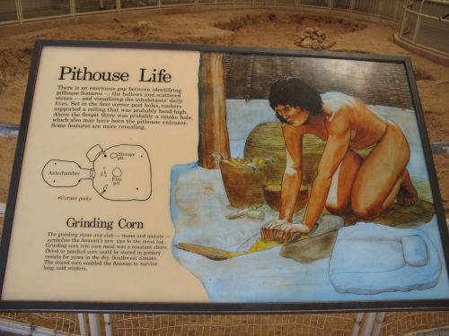
The Basketmaker III period (ca. AD 500 to 750) is a very important time for understanding the prehistoric Southwest.  Maize agriculture had been introduced earlier, although exactly how early is still a matter of debate, and it was definitely well-established by the immediately preceding Basketmaker II period, but Basketmaker III saw the introduction of beans, pottery, and the bow and arrow, all of which led to major changes in the lifestyles of local agriculturists.  Residence was in pithouses, which are clearly ancestral in form (and probably in function) to the “kivas” of later sites, and while these are usually found isolated or in very small groups, there are a few known examples of large “villages” containing dozens of pithouses.  The processes that led to the formation of these sites, as well as their relationships to the more common isolated sites, are very poorly understood, but it seems pretty clear that residential aggregation in certain locations during this period set the stage for the later formation of large villages during the succeeding Pueblo I period and afterward.

Two of the largest and best-known Basketmaker III villages are in Chaco Canyon.  The better-known of these, by far, is called Shabik’eschee Village, and it is located on the lowest terrace of a finger of Chacra Mesa at the east end of the current Chaco Culture National Historical Park.  Shabik’eschee was excavated by Frank H. H. Roberts in the 1920s as part of the Smithsonian/National Geographic project led by Neil Judd.  The main focus of the project was the excavation of Pueblo Bonito, but Judd had other members of the team, including Roberts, excavate several other sites in and around the canyon as well.  Roberts published his results in 1929, and this publication has been enormously influential in shaping subsequent interpretations of Basketmaker III villages and the period as a whole.

Looking South from Peñasco Blanco toward 29SJ423

The Chaco Project in the 1970s did some additional work at Shabik’eschee, as well as at the other Basketmaker Village in the canyon.  This site, known as 29SJ423, is just south of Peñasco Blanco at the far west end of the canyon, near the confluence of the Chaco and Escavada Washes.  It is situated in a similar location to Shabik’eschee, on a lower terrace of West Mesa (but above Peñasco Blanco, which is on the lowest terrace).  Tom Windes excavated a small portion of 29SJ423 in 1975, but he and other Chaco Project personnel soon came to the conclusion that additional excavation there would not be worth the considerable effort involved.  The collections from this excavation are important, however, since they were acquired using more careful, modern methods than Roberts’s.  Similarly, a very small amount of additional excavation at Shabik’eschee in 1973 has provided important supplemental information with which to evaluate Roberts’s interpretations.

Windes and Chip Wills published an article in 1989 looking back at Roberts’s interpretations at Shabik’eschee in the light of the additional knowledge gained by the Chaco Project excavations.  They concluded that some of Roberts’s ideas, such as his proposal that the site had two discrete periods of occupation separated by a hiatus during which it was abandoned, are likely untenable, and they also concluded that the site was considerably larger than Roberts thought.  They agreed with Roberts that some of the pithouses had been abandoned and their materials were used in subsequent construction, but they saw this as more of an ongoing process related to the short use-life of pithouses and the demands of demographic processes rather than a discrete series of two occupations.  They also saw more spatial patterning in the layout of pithouses within the site than Roberts did, suggesting that the pithouses grouped into what might be family residence units, although they were quite tentative in this finding and did not use these groups as units for any subsequent analysis.

Pinyon Trees, Pipe Spring National Monument

Wills and Windes also posited a novel interpretation for the site as a whole.  Rather than seeing it as a permanent agricultural village, they saw it as a site of occasional gatherings of more mobile families practicing a “mixed” subsistence strategy of small-scale agriculture along with hunting and gathering.  In their interpretation, a small number of families inhabited Shabik’eschee permanently, while others joined them periodically to take advantage of the site’s proximity to piñon woodlands in years with bountiful piñon-nut harvests.  They based this theory on the presence of two types of storage facilities at the site: household-level storage in the antechambers associated with some but not all of the pithouses (presumably the residences of permanent residents) and community-level storage bins scattered around the site.  The idea is that occasional surpluses of corn or whatever would be stored in the bins, and the people who lived at the site permanently watched over it and protected it.  Whenever there was a plentiful crop of piñon nuts, which happens at irregular intervals in the fall, people who lived the rest of the time in scattered locations throughout the area would congregate at Shabik’eschee to take advantage of this and stay for the winter.  If conditions in the spring were good for planting, people might stay longer and plant their crops in the area, but if not they would move on to more attractive planting locations.  Other pithouse villages, such as 29SJ423, would presumably have served similar purposes, allowing periodic aggregation to take advantage of various localized resources.

This is an interesting theory, but it’s based on exceptionally thin evidence.  Wills and Windes even concede that they are spinning this whole story purely from the nature of the storage facilities at the site, and they note that there are other ways to interpret the communal bins in particular.  Instead of protecting food stores during periods of reduced occupation, they may just have functioned to protect them in general.  The shape of the bins makes it more difficult to access their contents, which Wills and Windes interpret as evidence for a sort of semi-caching, but it would also just provide better protection from the elements, vermin, etc. for the contents.  Basically, there’s just no reason from the available evidence to buy the Wills and Windes theory.

"Pithouse Life" Sign at Mesa Verde

Indeed, the assumptions behind this theory seem problematic to me.  The ethnographic comparisons Wills and Windes use to support it are mostly from hunter-gatherer societies, and indeed their model seems to imply that the residents of Shabik’eschee were basically hunter-gatherers who did some farming on the side.  Such societies exist, and may well have existed at certain times in the ancient Southwest (such as the late Archaic), but recent studies have shown with increasing certainty that heavy dependence on agriculture was widespread already in the Basketmaker II period.  Wills and Windes seem to see the Basketmaker III inhabitants of the Chaco area as just beginning to experiment with adding agriculture to a hunter-gatherer lifeway, but it’s much more likely that they were full-time agriculturalists and had been for centuries.  They did of course still do some hunting and gathering, as their Pueblo descendants have continued to do up to the present day, but while this may in some sense qualify as a “mixed” economy that shouldn’t obscure the important fact that Pueblo societies have been overwhelmingly farming-based societies since well before the occupation of Shabik’eschee.

I think this interpretation, and others like it which were popular in Southwestern archaeology in the 1980s, results in part from the enormous influence of Lewis Binford on the development of processual archaeology.  Binford’s personal research and expertise were largely on hunter-gatherer societies, and the guidelines he set forth for “archaeology as anthropology” that were eagerly followed by young “New Archaeologists” were heavily influenced by that background.  Wills and Windes cite Binford several times in this article.

Excavating the Lift Station Site in the Chaco Maintenance Yard

Be that as it may, this is an important article just in providing an updated take on the facts about Shabik’eschee, which as Wills and Windes note has been very important in the interpretation of ancient societies generally.  It contains relatively little information about 29SJ423, but it does briefly discuss this site as a comparison.  It says even less about the much more numerous isolated Basketmaker III sites in the canyon, but it notes that Chaco Project surveys identified at least 163 pithouse sites from this period.  One that they didn’t find, because it was deeply buried under the ground, was later found by the park in the course of trying to build a lift station for the septic system.  This site, informally known as the Lift Station Site, is a Basketmaker III pithouse that was excavated while I was working at Chaco.  One of the more interesting things it revealed was an apparent location for pottery manufacture.

One of the major problems with trying to understand the Basketmaker III period at Chaco is precisely that the site are typically deeply buried, so it’s hard to even know how many of them there are.  It’s clear that this was a period of significant population in the canyon, but it’s hard to tell how many sites were occupied simultaneously.  This problem is exacerbated by the difficulty of dating many of the sites.  Tree-ring dates are often hard to obtain from the scarce wood found at excavated sites, and Shabik’eschee is particularly poorly dated.  The few tree-ring dates available seem to suggest it was occupied at some point after the mid-500s, but there are no cutting dates so any greater precision is impossible.  29SJ423 did produce two cutting dates, at 550 and 557, so it seems the two villages were most likely contemporaneous.  The isolated sites are even harder to date, of course, but the Lift Station Site produced corn that was radiocarbon dated.  I don’t know the dates that resulted, but I did hear that they were earlier than was expected based on the pottery types found.

Whole Pot from the Lift Station Site

The size of the Basketmaker III occupation at Chaco, and particularly the presence of the two large villages, has important implications for understanding the subsequent history of the canyon that I think are just beginning to be realized.  The local population seems to have declined during the subsequent Pueblo I period (ca. AD 750 to 900), when people seem to have begun to move in large numbers to higher elevations where they formed some really large villages.  However, it’s not clear that Chaco was completely abandoned during this period, and recent improvements in dating the early great houses in the canyon have shown that some of them, especially Pueblo Bonito, go back further than was once thought.  Pueblo Bonito is now known to have been begun no later than 860, and the earliest part of it may date much earlier, possibly to 800 or even before.  This means that the gap between the Basketmaker III villages and the earliest great houses suddenly looks a lot smaller, and may disappear entirely.  There are pithouses under the plaza at Pueblo Bonito that may date to very early Pueblo I or even Basketmaker III, and there is a small Pueblo I occupation at Shabik’eschee that dates as late as 750.  This suggests that these two iconic sites in Chacoan archaeology, generally interpreted in very different ways, may actually overlap in occupation.  This would require some serious modifications of the ways the origins of the Chaco system are often interpreted.

Chaco had been an important place for a very long time when it started to become a major regional center around AD 1040.  It’s looking increasingly plausible, though by no means certain, that it had been continuously occupied for 500 years at that point, and even if there was a brief gap between the Basketmaker III villages and the first Pueblo I great houses it is very unlikely that is was long enough for people to have forgotten about Chaco and what had happened there.  Even if many of the people who built and/or occupied the early great houses in the 800s hadn’t been born at Chaco, they probably knew it was there long before they made it their home.
ResearchBlogging.org
Wills, W., & Windes, T. (1989). Evidence for Population Aggregation and Dispersal during the Basketmaker III Period in Chaco Canyon, New Mexico American Antiquity, 54 (2) DOI: 10.2307/281711

Read Full Post »

Room 6, Pueblo Bonito

The “Chacoan era” is a period of about 100 years in the eleventh and early twelfth centuries AD during which Chaco Canyon was at the center of some sort of system that covered a large portion of the northern Southwest.  The exact nature and exact extent of that system are endlessly debated, but the period during which it existed is fairly well-established.  The exact dates given for the duration of the system vary among different researchers, and I’ve given various versions of them myself.  Probably the most common ending date is AD 1130, which coincides both with the approximate end of apparent construction in the canyon and the onset of a 50-year drought that is generally thought to have had something to do with the decline of Chaco.  To make it an even century, 1030 is a useful starting date for the Chacoan era, although it doesn’t actually correspond to anything special in the canyon as far as we can tell.  A better starting date might be 1040, which is approximately when the expansion of Pueblo Bonito began, or 1020, which is about when construction began at Pueblo Alto.  Using these starting dates with the hundred-year span gives ending dates of 1140 or 1120, which again are roughly equivalent to the end of major construction in the canyon.  (It’s a lot easier to date the beginnings of phenomena in the ancient Southwest than the ends of them, due largely to the reliance on tree-ring dates.)

Whenever we say the Chacoan era began, it was long after the first great houses in Chaco Canyon were built.  Indeed, the canyon had a long and probably very eventful history well before things really got going in the early 1000s.  During the 900s it may not yet have been important on as large a scale as it became later but it was definitely already a place where things were happening.  The origins of Chaco lie even earlier, however.

Type I and Type II Masonry Abutting at Peñasco Blanco

The first three great houses built in the canyon were Pueblo Bonito, Una Vida, and Peñasco Blanco.  Una Vida is mostly unexcavated and Peñasco Blanco is completely so, so the dating of them relies mainly on tree-ring sampling of exposed wood.  This has shown that these two sites probably date originally to the late 800s, with extensive expansion in the 900s.  The earliest cutting date at Una Vida is from AD 861, while Peñasco Blanco has a cluster of cutting dates at AD 898.  Both have clusters of dates in the 900s that suggest that much of the early construction dates to this period, and both also show expansion later, during the Chacoan era itself.  Beyond that, though, not much can be said about the chronology of these sites.

Pueblo Bonito is a different story.  It’s almost completely excavated, and while the excavation took place a long time ago, it left a lot more exposed wood than at most other sites.  The recent Chaco Wood Project, which sought to sample every piece of exposed wood in the canyon to develop as full a chronology as possible, had its most spectacular results at Bonito.  These were reported in part in an article in 1996 by Tom Windes and Dabney Ford, and the implications of the new dates for the architectural history of the site were more fully explained by Windes in a subsequent book chapter published in 2003.

Beams Sampled for Tree-Ring Dating in Room 227, Pueblo Bonito

To get a sense of the scale of this project, before it began in 1985 there were 163 pieces of wood from Pueblo Bonito that had been tree-ring dated.  By the time the 1996 Windes and Ford article was published, this figure had risen to 4,294.  That’s a big difference!  We now have a much better idea of when different parts of Bonito were constructed, and that has shed important light on developments in the canyon at large and their relationship to events elsewhere in the Southwest.

Before this project, Pueblo Bonito was thought to have been initially constructed in the early 900s, with some reuse of beams from earlier structures accounting for a handful of dates in the 800s.  This interpretation, expressed most influentially by Steve Lekson in his 1986 book on Chacoan architecture, was based largely on a tight cluster of cutting dates at AD 919 from Room 320 in the western part of “Old Bonito.”  The enlarged sample, however, showed that it was actually this cluster that was a fluke, and that other beams from this wing produced dates in the mid-800s that more likely represent the initial construction of this part of the site.  This seems particularly likely because the types of wood represented by these beams are largely piñon, juniper, and cottonwood, locally available species that were widely used early on, before the beginning of large-scale, long-distance procurement of large beams of ponderosa pine and other high-elevation woods.  This suggests that the beams in Room 320 which dated to 919 were probably replacement beams rather than original construction.  This block of rooms at the western end of Old Bonito was probably built around 860.

Room 320, Pueblo Bonito

Lekson thought this roomblock was probably the earliest part of the site.  As it turns out, it was even older than he thought, but evidence from other parts of Old Bonito suggests that it was not actually the earliest part.  A cluster of cutting dates at AD 891 in the northeast part of Old Bonito, which was clearly added onto the north-central part to the west of it, suggests that it was the north-central part that was actually first.  This makes sense just from looking at the plan of the rooms, actually.  This part of the site is less regular and formal in organization than the east and west wings of Old Bonito, and since it lies between them it seems logical that they would have been added on to the original central room suites.  This is a bit hard to interpret, however, since the places where these different parts of the Old Bonito arc would have come together are mostly buried under complicated later construction.

Windes suggests in his 2003 paper that the very oldest part of the site was the block consisting of Rooms 1, 2, 4/5, 6, 35, 36, 37, and 61.  None of these rooms produced wood that could be dated.  Room 6 contains a considerable amount of original wood, which can be seen today under a modern roof put on to protect it, but this is mostly cottonwood, which is very difficult to date.  As noted above, however, the use of local types of wood like cottonwood is a characteristic of very early construction at Chaco, so even though these beams couldn’t be dated they do still provide some evidence that this part of the site is very early.  The western roomblock, dating to around 860, was probably added onto this one.  This implies that the north-central block predates 860, and Windes says it is “probably much earlier” even than that (although he doesn’t explain why he thinks this).

Intact Roof Beams in Room 6, Pueblo Bonito

How much earlier?  It’s hard to say.  The earliest cutting date at Bonito is 828, from Room 317 in the western roomblock, which both Lekson in 1986 and Windes and Ford ten years later considered likely to be a reused beam.  Since the overall distribution of dates in this block suggests construction around 860, this is probably right, and it’s hard to say where the beam would have come from.  Probably not the north-central roomblock, which would probably have still been in use in 860.  Interestingly, this beam is of ponderosa pine.

The north-central roomblock could well date to around 800 or even earlier, and that brings us to an interesting point.  There are a bunch of pitstructures buried deep under later construction in what would have been the original plaza of Old Bonito; these were not extensively excavated, but they probably correspond to the room suites that make up Old Bonito and therefore date to the 800s.  There are two even earlier pitstructures, however, further south in the later plaza of the expanded Bonito.  Neil Judd, who excavated the site in the 1920s, didn’t pay much attention to them because he thought they were too early to have anything to do with Pueblo Bonito itself.  They apparently date to the Pueblo I or late Basketmaker III period.  Back when the consensus was the Bonito itself wasn’t built until 919, it made sense to agree with Judd that these pithouses were too early, but now that we know that the earliest parts of Old Bonito date well back into Pueblo I it starts to look more plausible that there is actually some continuity here.  Since Judd didn’t look very closely at the early pithouses, we have no way of dating them, which is unfortunate, but one possibility that is looking increasingly plausible is that there was no hiatus at all between the occupation of those pithouses and the earliest occupation of Old Bonito.  In that case, Pueblo Bonito as an important, inhabited location (rather than as the building we see today) might actually date back to Basketmaker III.  And, importantly, whoever lived there at that time wouldn’t have been alone in the canyon.  But that’s an issue for another post.
ResearchBlogging.org
Windes, T., & Ford, D. (1996). The Chaco Wood Project: The Chronometric Reappraisal of Pueblo Bonito American Antiquity, 61 (2) DOI: 10.2307/282427

Read Full Post »

Signs at Brookside Park Pool, Farmington, New Mexico

It seems my post on syphilis at Chaco has been selected for the current installation of Four Stone Hearth, the venerable anthropology blog carnival, hosted this time by Sam Wise at Sorting out Science.  I’ve had posts selected for FSH before, but it’s been a while.  Anyway, I’m honored, and I’d encourage anyone who’s interested in anthropology to take a look at the other selected posts.  There’s a lot of interesting stuff there.

Brookside Park Pool, Farmington, New Mexico

Read Full Post »

Aztec West Great House, Aztec Ruins National Monument

In the spring of 1892, an expedition headed by Warren K. Moorehead traveled through northwestern New Mexico to collect archaeological specimens for the Chicago World’s Fair to be held the next year.  Moorehead was a young man from Ohio who had already conducted considerable excavations there that had drawn the attention of Frederic Ward Putnam of the Harvard Peabody Museum.  Putnam hired Moorehead to collect artifacts in Ohio and elsewhere for the World’s Fair.  Moorehead’s Ohio work was important to the definition of the Hopewell Culture and the acquisition of the Fort Ancient site by the Ohio Historical Society, and by the time of his death in 1939 Moorehead was considered one of the preeminent American archaeologists.  He wrote up some of his observations from the 1892 New Mexico expedition in an article published in 1908 which contains some important early information about the archaeological remains along the Animas and La Plata Rivers before those areas were extensively developed.

Moorehead’s party surveyed the major ruins at Aztec, but John Koontz, who owned the site at the time, would not let them excavate there.  (This is an issue that would recur in Moorehead’s Southwestern adventures.)  The 1908 article contains a decent description and plan of the West Ruin at Aztec, including the observation of an obvious road leading to a nearby quarry site that was the apparent source of building stone.  The more important part of the article, however, deals with the La Plata, where the group spent more time and were apparently given permission to excavate several sites.  Moorehead noted very extensive irrigation systems along the valley bottom, which he suggested accounted for the numerous prehistoric sites and the apparently very large population they indicated.  Since the La Plata Valley has been extensively developed for modern agriculture since Moorehead’s time, these observations are very useful for understanding the perennially understudied archaeology of that area.  It’s not totally clear how many sites the group excavated, but Moorehead describes one burial with numerous associated pots and mentions a large, three-story site surrounded by many smaller sites.  This is probably the community now known as the “Holmes Group,” after William Henry Holmes, another early archaeologist who studied them.  Moorehead estimated about two hundred rooms in the community, half of them in the great house.

The Moorehead party excavated many graves and collected the pottery left with them, but Moorehead says that the bones themselves “were in such a state of decay that it was not possible to preserve them.”  The group also found an interesting vertical masonry shaft, fourteen inches square and eight feet, five inches deep.  The bottom of the shaft was paved with slabs and connected to a horizontal passage leading north, which Moorehead’s group excavated for about four feet before they “were compelled, unfortunately, to abandon the work; and thus were prevented from gaining sufficient evidence to determine the purpose of the structure.”  Moorehead doesn’t explain what compelled this stop to the digging.  He does speculate about the possible purpose of this shaft:

It could not have been a chimney, for neither the stones nor the logs showed signs of smoke or heat, although fragments of charcoal were found occasionally during the excavation; nor is it likely that the shaft was used as an air flue for the purpose of ventilation, both on account of the narrowness of the perpendicular portion (fourteen inches), and the apparent disregard manifested by the ancient Southwestern villagers of everything that might tend to promote hygienic conditions.

Zing!  In fact, this shaft almost certainly was a ventilation shaft associated with a kiva, similar to those documented by Jesse Walter Fewkes at Mesa Verde.  The fact that it led north is a clear indication, and Moorehead’s objection on the basis of size doesn’t make a whole lot of sense.  His snide comment about hygiene is odd, though perhaps indicative of the gentlemanly racism common among early anthropologists, and it would perhaps be unfair to tar Moorehead too much with it, as he actually was quite concerned with the fair treatment of Indians and worked hard throughout his life to advocate for their interests in a rather paternalistic way, which was not a common thing for archaeologists to do.  Still, he was a man of his times, and he was apparently unimpressed with the sanitary conditions of the modern Pueblos.

Opening of Vent Shaft to Kiva L, Pueblo Bonito

Moorehead’s attitudes may have been slightly more progressive than those of his archaeological contemporaries, but his methods weren’t.  His style of archaeology was very heavily based on recovering artifacts for his various patrons, first Putnam and later Robert Peabody, who made him head of the Robert S. Peabody Museum of Anthropology at Phillips Andover.  As shown by his 1908 article, he did do some documentation of the sites he investigated, but the focus was always on the artifacts rather than the sites.  The Ohio History Society’s short biography of him notes, rather defensively, that this was not uncommon at the time:

Moorehead sometimes is remembered unkindly for his supposedly crude excavation methods and for his involvement in the buying and selling of artifacts. Both criticisms are unfair. In the light of today’s standards his field methods certainly would be considered deficient, but for their time they were not all that unusual. The practice of buying and selling artifacts, particularly specimens considered to be duplicates, also was not unprecedented at the time.

This is true, but it’s not so much a defensive of Moorehead as an indictment of archaeology as a discipline at the time.  The contrast with Richard Wetherill and George Pepper’s excavations at Chaco in the 1890s is instructive.  Their methods are often defended along the same lines, but in fact compared to the likes of Moorehead they did a very good job of documenting their work.  Pepper’s site report on Pueblo Bonito, though based on his sometimes sketchy field notes and quite inadequate by modern standards, is a wonder of careful documentation of artifact contexts and room features compared to Moorehead’s typical work.  Furthermore, Wetherill was a skilled amateur photographer at a time when that was rare, and there are numerous photographs of the excavations at Bonito.  I don’t know of any other excavation projects in the 1890s that were photographed as systematically as those at Bonito.  Moorehead never took any pictures of his work as far as I know.

South Wall of Room 53, Pueblo Bonito

Indeed, we can compare Wetherill and Pepper’s methods directly with Moorehead’s, because Moorehead excavated at Pueblo Bonito too.  In 1897, Moorehead made another collecting expedition to the Southwest, this time on behalf of Peabody, and one of the stops he made was at Chaco Canyon.  Wetherill and Pepper had begun excavations at Pueblo Bonito in 1896, sponsored by none other than Frederic Ward Putnam, who was at this point affiliated with the American Museum of Natural History, and word of their spectacular finds such as the burials in Room 33 had probably gotten out.  In any case, Moorehead showed up at Chaco in the winter, the offseason for the AMNH party, and proceeded to tear the hell out of two rooms just north of Room 33.  These rooms, which Pepper would later designate Rooms 53 and 56, were apparently part of the same burial complex as Room 33, and they contained numerous burials and grave goods.  The grave assemblages were apparently not as elaborate as those in Room 33, however, and Moorehead was not particularly impressed with what he found (which is perhaps why he didn’t continue to excavate).  He did find one complete skeleton, wrapped in a feather robe, which he thought was of a young woman.  Nancy Akins, who reexamined the remains from Pueblo Bonito for the Chaco Project, concluded that this burial was actually of a man aged 40 to 44.  She also noted four skulls, now in the Field Museum, which were also probably from these rooms.  The Moorehead group didn’t fully excavate the rooms, and when Wetherill and Pepper returned in the summer they excavated what was left and sorted through the mess left by Moorehead, who had apparently thrown the fill from the rooms around haphazardly.  They found a few more artifacts and burials, but couldn’t say much about the original state of the rooms beyond noting two subfloor graves in Room 56 that Moorehead had opened.

Here’s what Akins had to say about Moorehead’s work in Rooms 53 and 56:

It is unfortunate that Moorehead plundered these two rooms. There are indications that a fair number of persons were buried in them. It is unlikely that they contained the amount of ornamentation found in Room 33, as none is mentioned by Moorehead in his report, little is listed in the Phillips-Andover catalog, and Moorehead stated that no remarkable
discoveries were made.

Moorehead did write an account of this expedition, which was published by Phillips Andover and is not easy to find.  I haven’t been able to read it, but judging from his 1908 article on the other expedition and Akins’s comments I don’t expect that it contained much detailed information on his work at Pueblo Bonito.

South Wall of Room 53 from Room 56, Pueblo Bonito

Also on this trip, Moorehead stopped by Salmon Ruin, where the landowner, George Salmon, only allowed him to dig for three days.  This frustrated Moorehead, and it indicates that Salmon, like John Koontz, was concerned with preserving his ruin and not letting archaeologists like Moorehead tear it apart wholesale looking for artifacts.  Obviously Salmon was a bit more accommodating than Koontz, who apparently didn’t let Moorehead dig at all at Aztec.

In the context of Chaco, and especially in comparison to Wetherill and Pepper, Moorehead looks pretty bad, but it’s worth emphasizing that he really wasn’t that unusual at the time.  The line between pothunter and archaeologist was really quite thin, and many archaeologists of Moorehead’s generation started out digging haphazardly for artifacts and later transitioned to more carefully documented digging for information.  Earl Morris is a good example of a pothunter who successfully turned himself into a serious archaeologist, and Richard Wetherill is an example of a sort of semi-pothunter who tried to make that transition but failed.  Moorehead’s background was similar, and he was more successful in ingratiating himself with the emerging academic archaeological establishment than Wetherill but probably less successful than Morris.  Part of the issue was just the change in archaeological practice over time; Wetherill died in 1910 (101 years ago today), whereas Moorehead lived until 1939 and Morris, who was of a younger generation, lived until 1956.

Interpretive Plaque at Wetherill Cemetery

Wetherill often gets cast as a villain in the story of Southwestern archaeology.  This is largely the doing of Edgar Hewett, who was an inveterate opponent of what Wetherill and Pepper were doing at Pueblo Bonito, which he characterized as large-scale looting.  Hewett’s line was eagerly adopted by the Santa Fe press, and it has become entrenched in popular understanding and even implicitly adopted by many archaeologists today.  It’s important to note, however, what Hewett was actually objecting to.  The biggest problem as he saw it was not that artifacts were being taken out of Pueblo Bonito but that they were being taken to New York, to sit in the AMNH (where most of them remain to this day).  Hewett wanted artifacts from Chaco not to stay at Chaco, but instead to be brought to Santa Fe and kept at his own institution, the Museum of New Mexico.  His characterizations of Wetherill and Pepper’s activities tended to carefully omit the involvement of the AMNH, which helped to drum up support for his cause among locals outraged by outsiders coming in and taking away artifacts.  Hewett eventually got his wish, and in the 1930s and 1940s he dominated archaeology at Chaco and throughout New Mexico.

Hewett’s success in tarring Wetherill as a pothunter shouldn’t blind us to the realities of the context Wetherill and Pepper were working in.  Their methods were crude compared to today’s, but within the range of variation in methods at the time they really were quite good, and much better than Moorehead’s crude methods.  Indeed, in some respects they were significantly better than the methods employed in Hewett’s own excavations at Chaco thirty years later.  The dispute between Hewett and Wetherill wasn’t about methods, and it wasn’t about “professional archaeologists” versus “amateur pothunters.”  Rather, it was a dispute between two groups of professional archaeologists and their institutional sponsors over who should be excavating at one of the most important archaeological sites in the region and which museum should get the artifacts they found.

Moorehead’s bit part in this drama really just serves as context, I think.  Despite the title of this post, I don’t think it’s really reasonable to cast him rather than Wetherill as the villain of the story.  Instead, Moorehead just illustrates that there was more to archaeology in the 1890s than Wetherill and Hewett, and that it is best to interpret the history of research at Chaco within that broader context.
ResearchBlogging.org
Moorehead, W. (1908). Ruins at Aztec and on the Rio La Plata, New Mexico American Anthropologist, 10 (2), 255-263 DOI: 10.1525/aa.1908.10.2.02a00080

Read Full Post »

Stone Tools at Chaco Visitor Center Museum

When it comes to stone tools, archaeologists make a basic distinction between “chipped-stone” and “ground-stone” tools.  Chipped-stone tools are generally those that need to be sharp, such as projectile points, knives, scrapers, and drills, and are typically made of hard stone that keeps an edge.  Some ground-stone tools, such as axes, are also sharp, but for the most part ground-stone tools rely on other qualities of stone for purposes like hammering and grinding.  In the Southwest, ground-stone tools are usually made of sandstone, basalt, or other types of stone that are plentiful in the area immediately around a site.  These tools are heavy, and it generally wouldn’t have made any sense to import special types of stone to make them when, as is the case throughout the Southwest, there were plenty of rocks around.  The types of stone used for ground-stone tools are also generally those used for masonry in areas where masonry construction was typical, including at Chaco, where sandstone was the usual material.

Chipped-stone tools are a different story.  They are usually small and highly portable, and the best materials to make them are often scattered and not convenient for every habitation site.  Thus, widespread trade in chipping stone has very early origins.  Hunter-gatherers need very good stone for their projectile points, and also tend to be very mobile, so their chipped-stone tools tend to be very well-made and to be made of high-quality material from a wide variety of sources.  Settled agriculturalists such as the Chacoans don’t rely so heavily on chipped-stone tools for their subsistence needs (ground-stone tools like metates are much more important), and they typically put much less effort into both procuring stone for chipped-stone tools and making the tools themselves.

Flake of Narbona Pass Chert at Pueblo Alto

When it comes to Chaco specifically, chipped-stone shows a much more muted form of the pattern of massive imports of other goods such as pottery, wood, turquoise, and even foodCathy Cameron summarizes the patterns revealed by the chipped-stone assemblages from Chaco Project excavations in the 1970s in an article from 2001.  The basic pattern is that most chipped stone was from local sources throughout the occupation of Chaco, although “local” really refers to a wider area here than the canyon itself.  Good chipping stone is not plentiful in the canyon itself, but abundant sources of good chert and petrified wood occur a few miles to the north and would have been easily accessible to canyon residents in the course of their daily lives (i.e., special trips to gather stone would probably not have been necessary).  These local sources always dominate assemblages from Chaco.  Imported stone types do increase during the Chaco era from AD 1030 to 1130, especially at great houses such as Pueblo Alto.  The most abundant import at this time is Narbona Pass chert, a distinctive pinkish type of stone that comes from a very restricted area in the Chuska Mountains to the west.  The Chuskas are also the source of many other imports to Chaco, including huge amounts of pottery and wood, but the relative proportions of Narbona Pass chert in the overall chipped-stone assemblages are much more modest.  It comprises 21.1% of the total Chaco Project sample for AD 1020 to 1120 and 18.9% of the sample for AD 1120 to 1220.  This is much higher than any other type of imported stone ever reaches, and even higher than any single type of local stone for these periods (though much lower than the total proportion of local stone).

Other imported materials found in notable numbers include Brushy Basin chert from the Four Corners area, a type of yellow-brown spotted chert and a special type of petrified wood, both from the Zuni area, and obsidian.  Brushy Basin chert (along with other materials from the same formation) and Zuni petrified wood reach relatively high proportions of the overall assemblage at the same time that Narbona Pass chert does, and Zuni chert does too but at a much lower level.  The pattern of obsidian is different, and hard to understand.  It’s the most common exotic type of stone before AD 920, rising to as high as 7.6% of the assemblage in the seventh century.  Sourcing studies seem to show that most of the obsidian coming it at this point came from the area around Grants, New Mexico, near Mount Taylor, during this period.  Once the Chaco system really gets going, though, the proportion of obsidian plummets to less than 1%.  From 1120 on, however, it rises again, comprising 7.3% from 1120 to 1220 and 2% after 1220, still less than Narbona Pass chert but respectable.  This obsidian seems to come mostly or entirely from sources in the Jemez Mountains to the east of Chaco.

Log of Petrified Wood at Chaco

So what were the Chacoans doing with this imported stone?  Not much, as it turns out.  One of the oddest things about the amount of Narbona Pass chert, particularly, is that it doesn’t appear to have been used for anything special.  Like all other types of stone, both local and imported, it was used primarily for expedient, informal tools.  The Chaco Project found 2,991 pieces of Narbona Pass chert, and only 18 of these were formal tools.  This pattern is typical for most material types, though obsidian seems to have been more often used for formal tools, many of which were probably imported as finished tools rather than made in the canyon.  Of the formal tools the Chaco Project did find, of all materials, about half were projectile points, and the rest were various types of knives, scrapers, and drills.

So what’s going on here?  Hard to say.  Cameron evaluates the chipped-stone data in the context of the models for the organization of production proposed by other participants in the conference from which this paper originated, and she decides that Colin Renfrew’s pilgrimage model fits best, with some adjustments.  This conclusion is driven largely by the fact that so much of the Narbona Pass chert came from the Pueblo Alto trash mound and the idea that this indicates that it was deposited there as part of communal rituals.  I find claims like this dubious, and I think it’s more likely that people in Chaco were just importing this type of stone either because it is so visually striking or because of their strong social connections to Chuskan communities (or both).

Chuska Mountains from Tsin Kletzin

The thing I find most puzzling is the obsidian.  Obsidian was hugely important in Mesoamerica, and in view of the appropriation and importation of many aspects of Mesoamerican culture by the Chacoans, most recently dramatized with evidence for chocolate consumption, it seems very odd that the rise of the Chacoan system would coincide with a steep decline in the amount of obsidian imported.  This is particularly odd since the Grants area was very much a part of the Chaco world, and there were numerous outlying great houses and communities near Mt. Taylor.  If the Chacoans had wanted obsidian, they could easily have gotten it.  And yet, it seems they didn’t.

Or did they?  Keep in mind that this data is based mostly on Chaco Project excavations, although Cameron does incorporate some insights from a study of formal chipped-stone tools done by Steve Lekson that incorporated other data as well.  Lekson’s study noted that Pueblo Bonito in particular had an astonishing number of projectile points relative to most other sites, and I can’t help but wonder if part of the lack of obsidian at other sites was a result of more of it flowing to Bonito.  The excavations at Bonito were done a long time ago without the careful techniques of the Chaco Project, so the data isn’t totally comparable, but I’m going to look at the artifact records from Bonito (conveniently made available at the Chaco Archive) to see how common obsidian was there.

Arrowheads at Chaco Visitor Center Museum

Speaking of projectile points, another thing Cameron mentions is that many of them seem to have been imported to Chaco, some of them apparently embedded in meat.  Others were particularly finely made and left in burials and caches, suggesting that they may have been specially made for votive purposes.  That’s probably the case for many of the points Lekson identified as being particularly numerous at Bonito, but what I want to know is why arrowheads were such common grave goods and offerings there.  Was there a particular association between Chaco and hunting?  The great house residents do seem to have eaten a lot more meat than other people in the canyon and elsewhere.

On the other hand, arrows weren’t only used for hunting.  Cameron notes that one projectile point found by Neil Judd at Pueblo Bonito was embedded in a human vertebra, and the Chaco Project also found a woman at the small site 29SJ1360 near Fajada Butte who had two points inside her.  We often talk about how peaceful Chaco was and how little evidence there is for warfare during the Chacoan era, but I’m starting to wonder about that.  It’s certainly true that Chaco itself and most other sites occupied during its florescence show less obvious evidence for violence than sites afterward do, but there are still some signs that things may not have been totally peaceful throughout the Southwest in Chacoan times.  Arrowheads in vertebrae don’t get there on their own, after all.  Who shot those arrows?
ResearchBlogging.org
Cameron, C. (2001). Pink Chert, Projectile Points, and the Chacoan Regional System American Antiquity, 66 (1) DOI: 10.2307/2694319

Read Full Post »

Fajada Butte from Pueblo Alto

Happy solstice, everyone.  To mark the occasion I figured I’d say a bit about archaeoastronomy, which is an important topic at Chaco that I don’t discuss very often.  The various alignments identified at the great houses in the canyon have become quite famous through the work of the Solstice Project to document them, and while I don’t think all of their proposed alignments are necessarily real, there is enough evidence by now to suggest that at least some of them are.  Cardinal direction alignments are the most obvious, and the least likely to be coincidental (in my view), and these are found at a few of the sites at Chaco, particularly Pueblo Bonito, Pueblo Alto, and Tsin Kletzin.  Interestingly, these three are all in the center of the canyon (“Downtown Chaco”), and the line running due north-south from Pueblo Alto to Tsin Kletzin runs between Pueblo Bonito and Chetro Ketl through the “Chaco Amphitheater.”  This all suggests some pretty extensive planning, but it’s interesting that the other parts of the canyon don’t seem to have been part of it.  I find the Solstice Project’s proposed alignments at many of the other sites in the canyon a lot more dubious, especially since so many of them are allegedly to the minor lunar standstill.  It seems more plausible that there would be solstice alignments in the canyon, and there do indeed seem to be some “viewing points” from which solstice sunrises are marked by prominent features on the horizon, but the only solstice-aligned building proposed by the Solstice Project is Aztec West, which isn’t even at Chaco, although it’s clearly Chacoan in style.

Steve Lekson has proposed that one possible reason for the variety of alignments in Chacoan great houses is conflict between factions within Chacoan society.  The way he sees it, solstice alignments were the regional tradition, and cardinal alignments were a new idea at Chaco, perhaps threatening to the old order in the way that many new developments at Chaco were.  Indeed, alignment to the southeast was a common architectural practice in pre-Chaco communities, and this may well have had something to do with the solstices, although as far as I know none of these buildings have been demonstrated to have precise solstitial alignments.  I’m not so sure that cardinal direction alignments were not present in the region before Chaco, however, and I’m also unsure of whether differences in building orientation really represent ideology the way Lekson proposes.  I’m more inclined to wonder if they may instead reflect different ethnic or regional origins for different groups.  In either case, though, the factionalism idea is interesting, and quite compatible with what we know of later Pueblo societies.  In Lekson’s version, the solstice alignment of Aztec reflects the founding of that center by the solstitial faction at Chaco, while the cardinal faction went elsewhere, maybe to Paquimé, which has a strong cardinal alignment.  I’m not sure how much of that I buy, but it’s worth thinking about.

Pueblo Alto and New Alto from Tsin Kletzin

Read Full Post »

Whiteware Sherd at Una Vida

Pottery is the most important type of artifact for archaeology in the Southwest.  This is because the agricultural societies of the prehistoric Southwest made huge numbers of pots and often decorated them in distinctive ways that differed both from place to place and over time, often within quite short periods.  With the precision available from tree-ring dating, certain pottery types can be dated to remarkably short periods, in some cases consisting of less than 100 years, and those types in turn can be used to date unexcavated sites with no tree-ring dates of their own.  Differences in decoration over time are more obvious than differences among places for most periods, which is an interesting fact that probably deserves more attention than it has gotten.  Ceramic design styles changed at roughly the same times over amazingly large areas that in some cases don’t show any other evidence of substantial contact.  During the Chaco era, from about AD 1030 to 1130, the dominant design style throughout the northern Southwest used a lot of hachure, for example.  The specific types have different names, assigned to them by archaeologists working in different regions, and despite the general similarity in design these can be distinguished by distinctive aspects of their manufacture.  These include the type of clay used for the vessel (known as the “paste”), the presence and nature of an additional type of clay (the “slip”) put on top of the paste especially for painted types, the type of paint used, and the material used to temper the clay.  Tempering is the addition of some material to the paste to make it easier to work.  Almost all Southwestern pottery types are tempered, and the type of tempering material is one major way different regional wares are distinguished.

To make this more concrete, let’s look at the Cibola pottery tradition, to which Chaco’s pottery belongs.  There are two “wares” within this tradition: Cibola white ware and Cibola gray ware.  The gray ware is the “utility ware” used for cooking pots and other mundane vessels.  It is never painted, and when it has any type of decoration this typically consists of some sort of corrugation.  Types of corrugation vary over time.  During the height of the Chaco era, the dominant type was corrugation all over the vessel, whereas in earlier times only the neck would be corrugated.  Corrugated sherds are very common at Chacoan sites, because these vessels were made in large numbers, broke frequently from heavy use, and were mostly large jars that broke into many pieces.  Vessels forms are almost entirely jars rather than bowls.  Temper is typically either sand (in some cases probably from ground-up sandstone) or ground-up sherds.

Black-on-white Sherd at Pueblo Alto

Cibola white ware is more complicated.  This is the main “decorated” ware made at Chaco and in the area to the south of it.  These vessels have the same sand- or sherd-tempered gray paste as the gray wares, but the decorated surface also has a white slip that gives vessel a white appearance from the exterior.  The slips are thin and often applied in a sort of “washy” manner, and in some cases the gray paste can be seen beneath them.  Designs are painted on with mineral-based paint (usually made with iron oxide), at least until about AD 1100.  Forms are both jars and bowls.  Jars are decorated on the exterior, while bowls are usually decorated on the interior.

Similar gray and white wares are present for most other regions during the same period.  San Juan gray and white wares were made north of the San Juan River and are distinguished primarily by the use of crushed volcanic rock rather than sand or sherds as temper.  The white slips on the white ware are also thicker and often highly polished.  To the west, in the Kayenta area, white wares were generally painted with organic (carbon-based) paints, and over time this practice spread eastward, until after 1100 it was common in the Cibola and San Juan areas as well.

Chuska Mountains from Peñasco Blanco

A particularly important ceramic area for understanding the Chaco system is the Chuska Mountain area to the west, along the Arizona-New Mexico border.  In regional ceramic terms this area basically separates the Cibola and Kayenta traditions, and in some ways it was transitional between the two.  Chuskan potters adopted carbon paint earlier than those in the Cibola and San Juan areas, so imported white wares from the Chuskas to Chaco are typically carbon-painted although the designs on them are generally the same as local types.  The thing that really distinguishes Chuska pottery, though, is temper.  Chuskan ceramics are nearly universally tempered with trachyte, a rare and very obvious type of volcanic rock that outcrops only in a small area in the Chuskas.  Trachyte-tempered pottery is therefore virtually guaranteed to have been imported from the Chuskas.

Why is this?  Because potters are generally thought to have used local materials for temper (and for clay, but pinpointing clay sources is much more difficult).  Designs might be similar over a wide area, but if the temper in a vessel is a material only found in a very restricted area, it’s virtually certain that the vessel was made near there.  Unfortunately, most of the materials used for temper in the Southwest are very widespread; there’s sand everywhere, sherds would be present wherever anyone had broken pottery (so, again, everywhere), and the types of volcanic rock used in the San Juan region were quite widespread.  Luckily, however, trachyte-tempered Chuska pottery is an exception to this, which makes it very easy to identify imports from the Chuska area at Chaco and elsewhere.

Corrugated Grayware Sherd at Wijiji

There are other ways to determine the source areas for pottery.  X-ray fluorescence (XRF) and instrumental neutron activation analysis (INAA) are two widely-used methods of determining clay sources by the concentrations of trace elements in sherds, but they are very expensive and the results can be difficult to interpret.  Some studies using these techniques have been done in the Southwest, and a database of element concentrations for different source areas is beginning to develop.  At Chaco, however, analysis of pottery sources has so far depended primarily on the more traditional techniques of looking at paint, slip, and especially temper.  The biggest study was that done in connection with the Chaco Project, the results of which were presented in a 1997 publication by Wolky Toll and Peter McKenna (available on the Chaco Archive website).  Some of the data from this study was also used by Toll in his 2001 article that I have discussed before.

In brief, what Toll and McKenna found was that the Chacoans imported a lot of pottery.  The amounts of imports and their sources varied over time, however.  Imports were relatively rare before AD 800, making up 16.6% of the sample, but they came from a variety of sources, including the Chuskas, the San Juan region, and the Mogollon region to the south, which has very distinctive brownwares that are obvious imports when they appear.  Trachyte temper is only present in 3.6% of the total sample.  The period from 800 to 920 has a rather small sample from the Chaco Project excavations, but an increase in imported ceramics is apparent, with 28.1% imports and 9.7% trachyte-tempered.  The most common non-local temper, however, was chalcedonic sandstone, thought to come from the area to the south of Chaco, which comprised 13.2% of the ceramics from this period.  This is consistent with other evidence for intense contact with the area to the south at this time.

Pots from Early Periods at Chaco Museum

From 920 to 1040, overall imports drop slightly to 25.1%.  Chalcedonic sandstone drops to 7.9%, while trachyte rises to 12.3%, the highest percentage for any specific type of import.  This trend continues in the following period, from 1040 to 1100, which corresponds to the height of the Chaco system and the construction of most of the great houses in the canyon.  The overall percentage of imports rises to 39.8%, with almost all of that (30.7%) being trachyte-tempered.  It’s well-known that many other goods were being imported from the Chuskas at this time, especially wood, so it’s not surprising that Chuskan pottery would also have been popular.  There were a lot of Chacoan great houses and communities in the Chuska area, which seems to have been closely integrated into the overall Chacoan system, perhaps to a greater degree than other “outlying” areas.  The shift from south to west in the focus of the system seen in the pottery data is echoed in other types of evidence from this period.

The trend toward higher imports reaches a peak in the 1100 to 1200 period, which includes the end of Chaco’s regional dominance (but perhaps also its peak).  Imports constitute an astonishing 50.4% of all the ceramics from this period, and trachyte-tempered pots comprised 31.3%, a gain in overall percentage from the previous period but a loss relative to other imported types.  Chalcedonic sandstone continued to decline, while Kayenta wares increased to 4.8% after never having exceeded 1% before.  It’s important to note, however, that the sample from this period is much smaller than that for the previous period and it may not be totally representative.  The last period, from 1200 on, has a very small sample but continues to show a high percentage of overall imports (45.7%).  Trachyte drops to 21.6%, and San Juan wares skyrocket to 16.4% after never having exceeded 5% before.  This shift to the north for ceramic sources surely has to do with the relative decline of Chaco in this period and the rise of centers to the north, especially Aztec, which probably succeeded Chaco as the center of whatever Chaco had been the center of.  This is also the period during which Mesa Verde became a major population center, but despite the fact that the main decorated white ware type is known as “Mesa Verde Black-on-white” it’s unlikely that many of the San Juan wares found at Chaco came from Mesa Verde itself.  It’s much more likely that they came from Aztec or elsewhere in the Totah area, which had much closer ties to Chaco than Mesa Verde proper ever had.

Pots from Later Periods at Chaco Museum

So basically, the pattern that emerges from the ceramic data is of a shift in imports from the south to the west as the Chaco system really got going, followed by a shift to the north as it faltered or changed.  This is paralleled in other types of artifacts, as well as in settlement patterns.  The outlying communities to the south in the Red Mesa Valley were being abandoned in the late eleventh century even as new outliers like Salmon were being built to the north.  There are enough lines of evidence pointing in this direction to suggest that it corresponds to something real, but it’s hard to say what exactly was going on and why.

It’s also important to note the weaknesses in this analysis.  Remember, this is Chaco Project data.  It doesn’t include any of the pottery excavated from Pueblo Bonito, Chetro Ketl, Pueblo del Arroyo, or any other sites excavated prior to the 1970s.  It also has a heavy bias toward data from Pueblo Alto, which as I’ve mentioned before can be problematic in overall interpretations of Chaco.  However, at least the heavy importation of Chuska wares does seem to be supported by data from Pueblo Bonito.  Anna Shepard, the ceramic analyst who pioneered many of the techniques that are now standard in the Southwest, analyzed the sherds from Neil Judd’s excavations at Bonito in the 1920s and concluded that many of them were imported from the Chuskas based on the presence of trachyte temper.  Judd, who was heavily devoted to the currently prevailing notion that Pueblos were self-sufficient for utilitarian goods like pottery, was so skeptical of this finding that he actually wrote a rebuttal to Shepard’s analysis and published both in his report.  As it turns out, however, Shepard was right, and ahead of her time, in seeing substantial importation of pottery to Chaco.

Corrugated Grayware Sherds at Kin Ya'a

Of course, this leaves open the question of why the Chacoans would have imported so much pottery.  Was it due to a shortage of materials?  Surely there was no shortage of clay or sand; Chaco may be lacking in most resources, but it has virtually inexhaustible supplies of clay and sand.  Wolky Toll is inclined to think that a shortage of fuel for firing may have been a factor, and that the heavily forested Chuskas may have been a better place to find fuel and thus to make pots.  Certainly local wood resources in the sparsely wooded area around Chaco would have run out quite quickly what with all the monumental construction, but I don’t really buy this.  Wood isn’t the only type of fuel you can use to make fires.  There is plenty of evidence that the Chacoans burned corncobs and other material in their domestic hearths, and Toll and McKenna refer in their report to an apparent pottery production location in the Chuskas, dating to Basketmaker III times, that was not near wood sources but did have “complex hearths with substantial fuel waste build up (primarily corn stalks).”

So if not for lack of fuel, why all the imports?  One clue may come from the types of vessels imported.  The Chuska imports were primarily gray ware utility vessels, which were used for cooking.  It has been proposed that trachyte provides better resilience to thermal shock from repeated heating and cooling than other tempers, and Chuska vessels may thus have been higher-quality cooking pots than other local or imported vessels.  (Similar arguments have been made for the superiority of corrugated pots as compared to plainwares.)  This is certainly possible, but in light of the numerous other Chuskan imports it’s not really clear to me that functional considerations were primary determinants of Chacoan trade patterns.  Maybe the Chacoans just had particularly close social and political ties to Chuskan communities, and that led to closer economic ties.  A lot of this depends on the nature of the Chaco system, which of course we don’t know much about.

In any case, the large-scale importation of pottery is one of the most striking examples of how Chaco was very much at the center of a regional system.  We may not know what that system was, exactly, or how it functioned, but we can see that it existed.  The evidence is right there in all those potsherds that litter the ground around the sites in the canyon.
ResearchBlogging.org
Toll, H. (2001). Making and Breaking Pots in the Chaco World American Antiquity, 66 (1) DOI: 10.2307/2694318

Read Full Post »

Train Station, Dolores, Colorado

Southwestern archaeology, especially in the Chaco area, is structured chronologically primarily by the Pecos Classification.  This system was initially worked out at the first Pecos Conference in 1927, and it was originally interpreted as a series of stages in cultural development, with the assumption that sites with similar characteristics and material culture were roughly contemporaneous.  Once tree-ring dating became available, however, it became clear that this wasn’t quite true, and furthermore that different sub-regions of the Southwest went through the stages at different times.  There have been a variety of approaches developed in the decades since to either redefine the Pecos system or abandon it.  In the Four Corners, the main approach has been to just recast the Pecos stages as chronological markers without any inherent cultural content.  The exact dates used for each stage vary by specific area and specific researcher, but here’s a rough outline of how they are often defined:

  • Basketmaker II: 500 BC to AD 500
  • Basketmaker III: AD 500 to 750
  • Pueblo I: AD 750 to 950
  • Pueblo II: AD 950 to 1150
  • Pueblo III: AD 1150 to 1300
  • Pueblo IV: AD 1300 to 1540

There’s no Basketmaker I.  The Pecos Conference attendees were unsure what, if anything, came before Basketmaker II, and they provisionally included an earlier stage in case there did turn out to be earlier sites.  As it turned out, there were, but they were sufficiently different from Basketmaker sites that they ended up being considered part of the Archaic period of hunter-gatherer societies predating the introduction of agriculture.  (Recent discoveries have begun to muddle this picture, at least for certain areas, but while not everyone still uses the term “Archaic” for the period just before Basketmaker II no one has yet begun to call it “Basketmaker I.”)

Camping at McPhee Campground for 2009 Pecos Conference

Although the stages are generally interpreted as chronological rather than developmental these days, there is still a general sense of what sorts of sites are “typical” or expected for each stage, and this has driven a lot of the variation in specific date ranges.  Basketmaker II sites are generally associated with corn and squash agriculture, a scattered settlement pattern, lots of basketry but no pottery, and the use of the atlatl.  In Basketmaker III this pattern was adjusted by the introduction of the bow and arrow, pottery, and beans, and people began to cluster in some cases into pithouse villages, although there were still many isolated hamlets in some areas.  Pueblo I was something of a transition between Basketmaker III and Pueblo II, with the first construction of significant above-ground architecture in addition to pithouses.  Pueblo II was associated with masonry roomblocks and kivas, generally organized as “unit pueblos” of a few rooms with a kiva and trash mound in front and loosely grouped into “communities.”  The height of Chaco dates to this period, and within the area of Chacoan influence these communities typically had great houses in addition to the unit pueblos but separate from them.  In Pueblo III people began to aggregate into larger, denser communities more like the “pueblos” of historic times.  The cliff dwellings at Mesa Verde and elsewhere date to this period and are the best known of these aggregated sites, but there were many others in a variety of locations.  At the end of the Pueblo III period almost all of the Four Corners area was abandoned and people aggregated further into even larger pueblos in the Rio Grande Valley and the Zuni and Hopi areas to the west, in addition to a few other areas.  The Pueblo IV period is marked by the increasing concentration of population into ever-larger sites and the clustering of these sites in particular areas separated from other clusters by uninhabited “buffer zones.”  This period also saw the apparent introduction of the kachina cult and various other novel social phenomena, and it continued until the Spanish showed up and smashed everything.

That’s the picture in a nutshell, but some periods are better-known than others.  Pueblo II and III have been particularly well-researched in the Chaco and Mesa Verde areas, although there is still plenty that remains unknown about them.  In contrast, Pueblo I was very poorly understood until the Dolores Project in the 1980s totally revolutionized our knowledge of it.  This project was a massive cultural resource management (CRM) salvage project in advance of the damming of the Dolores River and the creation of McPhee Reservoir.  At the time it was the largest CRM project ever, and it might still have that distinction.  Numerous sites in the Dolores River Valley were excavated carefully and thoroughly documented.

McPhee Reservoir from McPhee Campground, Site of 2009 Pecos Conference

It’s impossible to overstate how much our current knowledge of the Pueblo I period is based on the discoveries made at Dolores.  What the project found was that the Dolores Valley, although sparsely occupied both before and after Pueblo I, during Pueblo I contained numerous large, dense villages, most of which only existed for a very short period of time during the AD 800s.  As research continued throughout southwestern Colorado, it became more apparent that these villages were just part of the story of the incredibly dynamic Pueblo I period.  People were moving all over the place, very rapidly, and forming and dissolving villages within the space of one or two generations.  Abundant evidence for drought and conflict at certain key points during the period provided some explanation for why, but the really important thing that came out of the Dolores Project specifically was the detailed study of some of the specific villages that allowed reconstruction of their short histories with remarkable precision.

On a larger scale, it appears that the Pueblo I period involved the movement of people into higher elevations than they had occupied during Basketmaker III, followed by movement back down after 900 and into Pueblo II.  While areas with Pueblo I villages typically didn’t have substantial earlier or later occupations, many other areas (including Chaco) had major Basketmaker III and Pueblo II occupations but little evidence of use during Pueblo I.  This probably had to do with climatic changes, but there were clearly also a lot of social processes going on as well.  Since the rise of Chaco as a regional center began right after all of this, Chacoan specialists have been realizing recently that the evidence from Dolores is very important as background for understanding Chaco.

McPhee Reservoir, Dolores, Colorado

Particularly influential in shaping understandings of Chaco has been one of the Dolores villages in particular, known as McPhee Village.  Like the other Dolores villages, McPhee was founded around 840 as people began to move out of earlier villages further south around Mesa Verde and Durango.  Not everyone from these earlier villages went to Dolores (an important point), but many did, and the Dolores villages grew rapidly, only to decline just as rapidly as people moved out starting in the 870s and continuing until around 900, at which point there was only a very small remnant population in some of the villages.

The remarkable thing about McPhee Village was the presence of some roomblocks there that bore an uncanny resemblance to the early “great houses” that would arise in the San Juan Basin to the south, including at Chaco, shortly afterward.  Not all of the roomblocks were like this; most were small, linear unit pueblos typical of those in most other villages.  Two roomblocks in particular, however, known as McPhee Pueblo and Pueblo de las Golondrinas, looked astonishingly like the early form of Pueblo Bonito.  They were arc-shaped rather than linear, with two arcs making up McPhee Pueblo and Pueblo de las Golondrinas consisting of one larger arc.  (Note that “McPhee Pueblo” refers to a specific roomblock within “McPhee Village.”  The terminology is confusing.)  Furthermore, these roomblocks were made up of room suites consisting of three rooms, with one large room facing the “plaza” within the arc backed by two smaller “storage” rooms.  The “plaza” area within each arc contained pit structures presumably associated with these suites.  Again, this is much like the layout of Pueblo Bonito and other early Chaco great houses.  These roomblocks were also made largely of masonry rather than adobe, in contrast to most earlier sites as well as many other Dolores villages, which again linked them to the later Chaco sites.

Dolores Medical Center, Dolores, Colorado

A variety of studies have been done of these sites, particularly focused on what differentiated them from other roomblocks at McPhee Village.  James Potter did a study of animal remains at McPhee Pueblo and Pueblo de las Golondrinas, looking for evidence that the residents of these sites might have hosted community-wide feasts and/or conducted special rituals, either of which could have been ways for them to gain social power within the community.  Both sites contain, in addition to the standard residential pitstructures common at all sites in the village, special “oversized” pitstructures with more formal, elaborate features that could have served as special locations for feasts or rituals.  He found that McPhee Pueblo did indeed have a much higher number of different types of animal remains present, including many “non-economic” species such as carnivores and certain birds that may have had important ritual uses.  Furthermore, it had a higher proportion of rabbits than most other roomblocks, which is significant because among the modern Pueblos rabbits are often hunted communally and eaten in ritual feasts.  Interestingly, Pueblo de las Golondrinas, despite its size and the presence of an oversized pitstructure, did not have these characteristics, suggesting that its inhabitants may not have been as successful as those at McPhee Pueblo at hosting communal rituals and increasing their power.

Another take on this question comes from an analysis of ritual architecture by Gregson Schachner.  Starting from the assumption that times of significant environmental and social change, such as those that surely accompanied the rapid founding and dissolution of the Dolores villages, offer opportunities for ambitious individuals or groups to gain power and influence by taking control of ritual practices or introducing new ones, he noted that unlike some other Dolores villages McPhee Village doesn’t have a great kiva, the standard community ritual structure both before and after the Pueblo I period.  Instead, roomblocks like McPhee Pueblo and Pueblo de las Golondrinas have the oversized pitstructures that might have been used for special ritual practices that the inhabitants of those sites may have tried to introduce to their communities. Schachner assumes that these pitstructures were primarily ritual rather than residential, which I think is dubious, but otherwise his arguments make sense.  He basically sees the process as having involved certain individuals or groups having tried to introduce new rituals that gave them increased status and power in the context of the convulsions of the Pueblo I period.  Those rituals might have been adopted because they offered a new way forward during the drought that coincided with the founding of the Dolores villages in the 840s, but they might have lost their appeal as a new drought in the 880s led people in the village to reject the innovations of these would-be leaders.  As the village dissolved, construction seems to have begun on a new great kiva over the oversized pitstructure at Pueblo de las Golondrinas.  This great kiva was not completed, however, and the whole village was soon abandoned.  Great kivas continued to be a key part of the new villages further to the south that appear to have absorbed many of the people leaving Dolores after 880, but the oversized pitstructure does not seem to have continued as a recognizable architectural form.

Mac's Plumbing, Dolores, Colorado

The great house form, however, which began to proliferate in the San Juan basin starting in the tenth century, seems to have some connection to the arc-shaped roomblocks at Dolores.  Recently, a model for the rise of Chaco incorporating the insights of the Dolores Project has begun to gain increasing acceptance.  Under this model, the frustrated would-be elites from the Dolores villages moved south into Chaco and other communities and began to build similar structures to those they had lived in at Dolores.  This time, however, circumstances were better, and they were able to gain more control over their communities.  These communities were spread throughout the basin, but those in Chaco Canyon specifically eventually gained ascendancy over the others, and the Chaco Phenomenon was born.

There is a certain logic to this, and parts of it are likely true, but it’s important to note that the timing isn’t quite right for frustrated elites from Dolores to have founded the first great houses at Chaco.  The earliest parts of Pueblo Bonito are now thought to have been built by 860 and perhaps considerably earlier, while the Dolores villages didn’t start to dissolve until the 870s.  It’s quite possible that later additions to the site in the 890s and early 900s involved immigration from Dolores, and indeed it is these room suites that are particularly similar to those at McPhee Pueblo.  It’s worth considering, however, the possibility that the early history of Chaco involved people moving in from the south as well as the north, and we don’t know nearly as much about the Pueblo I period in that area.  Were there large, unstable villages with ambitious families or individuals there too, or was something totally different going on that led people to head north at the same time people were heading south from Dolores?  We can only guess at this point, but it’s important not to let our greater knowledge of developments at Dolores lead us to focus too much on it to the exclusion of other important areas.  Dolores was very important, no question, but it wasn’t the only important place at the time.
ResearchBlogging.org
Potter, J. (1997). Communal Ritual and Faunal Remains: An Example from the Dolores Anasazi Journal of Field Archaeology, 24 (3) DOI: 10.2307/530690

Schachner, G (2001). Ritual Control and Transformation in Middle-Range Societies:
An Example from the American Southwest Journal of Anthropological Archaeology, 20, 168-194 DOI: 10.1006/jaar.2001.0379

Read Full Post »

Room 38, Pueblo Bonito

Pueblo Bonito is the best-known and most-studied site at Chaco, but there’s still a lot we don’t know about it.  Because it was excavated early in the history of Southwestern archaeology, provenience information for the vast numbers of artifacts found at Bonito is not nearly as precise as would be expected today.  We do generally have information about what was in each excavated room, and often where in the room specific artifacts were, but the careful stratigraphic approaches used today were either totally unknown or in their infancy during the excavation of various parts of Bonito, so interpreting the field notes and site reports can be a challenge.  Partly for this reason, a lot of recent interpretations of Chaco have been based mainly on the more recent and better-documented excavations by the Chaco Project in the 1970s.  This makes Pueblo Alto in particular, the only great house extensively excavated by the Chaco Project, enormously influential in recent interpretations, not always in beneficial ways.  The Pueblo Bonito data has been incorporated into most theories to varying extents, but this often just takes the form of vague gesturing at the elaborate burials and huge quantities of high-value artifacts found there, and sometimes it basically amounts to discounting the importance of Bonito because it is so unlike the other sites.

Still, Bonito is important!  The problematic nature of the documentation notwithstanding, there’s still a ton of data available, and the Chaco Archive has been doing excellent work lately in making it more widely accessible.  Their cool interactive map of the site even allows you to click on a room and see a list of all the features, artifacts, tree-ring dates, and pictures associated with that room.  I’ve been playing around with it a lot lately, and there’s really a ton of interesting stuff in many of the rooms that we don’t hear so much about.

Room 309, Pueblo Bonito

Building on what I was saying earlier about a badger burial at a small site excavated by Earl Morris near Aztec, I decided to look for unusual animal burials or remains that might suggest some patterns in ritual practices or group identities at Bonito.  Many modern Pueblo clans are named after specific animals, and it seems reasonable that some Chacoan social groups (which may or may not be equivalent or ancestral to the modern clans) might have had similar identities that would lead them to leave animal remains in certain contexts that could indicate connections through time between different rooms or sites.  The Chaco Archive database allows you to search for specific types of artifacts, and it even has a special option for non-human burials.  The database doesn’t have all the sites included yet, but it does have all of Bonito, and it’s a powerful tool for finding information about the sites that are included.

Starting with the non-human burials, the ones at Bonito seem to all be of macaws and parrots.  The close connection between Bonito and macaws has long been noted, and Room 38 is particularly known for its large numbers of them, but one thing I hadn’t realized is that, like so much else at Bonito, the distribution of macaws is highly concentrated, not just in a few rooms, but specifically in a few rooms on the east side of the site.  The macaw burials, in addition to the two in Room 38, are in Rooms 71, 78, and 306, all of which are in the eastern part of Old Bonito.  Not all of these are actually formal burials, but they are all complete skeletons.  Extending the search to individual bones adds Rooms 249, 251, 309, and 312, as well as Kiva J and the east mound in front of the site.  Again, these are all on the east side of Bonito, although not just in Old Bonito this time.  Rooms 309 and 312 aren’t technically in Old Bonito, but they are among the rooms added right in front of it, and are very close to Rooms 306, 71, and 78, which also had macaws.  Rooms 249 and 251 are in the block of rooms added onto the southeast part of the site over an earlier extension that apparently built over part of the eastern end of Old Bonito (this part of the site is very complicated and its construction sequence is poorly understood).  Kiva J is one of the six blocked-in kivas between this block and the plaza.  And, of course, the east mound is the easternmost of the two mounds.

Kiva J, Pueblo Bonito

What does all this mean?  Many have suggested that the number of macaws at Bonito indicates the possible presence of a macaw clan like the one known today at Zuni.  If this is indeed the explanation for all the macaws, and it seems plausible given the restricted distribution of them to just a few sites at this time and the contexts in which they are found, it seems that this clan probably lived in or had claims on the eastern part of Pueblo Bonito, and that this association held not just in the earliest stages of the site but even after it was expanded.  Perhaps members of this clan were the initial residents of the eastern suites in Old Bonito, then when those rooms were converted to other uses as the site was expanded they moved into the new southeast wing.

One question that might be raised at this point is whether this distribution is actually specific to macaws.  Maybe all exotic birds and animals are concentrated in this part of the site, which would suggest that there might be something special about the eastern half of the site but not necessarily anything tied to a specific clan.  Some research into the layout of the rooms has shown that the southeast corner is unusual in not being divided into obvious room suites, whereas the southwest corner seems to be.  Maybe instead of the macaw clan living in the eastern half, everyone lived in the western half and they used the eastern half for macaw-related (and other) ritual.

Room 330, Pueblo Bonito

One way to test this would be to look at other unusual animals.  Finding animals of ritual importance beyond obvious exotics like macaws is tricky, because many animals were certainly used for mundane purposes and their remains are therefore all over.  Dogs and turkeys were kept domestically, so their remains probably wouldn’t indicate anything special about social groupings, and game animals such as rabbits and deer might have interesting implications for access to different kinds of meat but, again, not necessarily specific symbolic implications.  That basically leaves animals that don’t serve a clear subsistence or other utilitarian purpose but are nevertheless found in sufficient numbers to suggest something more than mere chance is behind their presence.  The best example I’ve found: bears.

You basically never hear about bears in discussions of Chaco.  They are not present in the area now and probably weren’t in antiquity either, and their remains are certainly rare at Chaco but not entirely absent.  At Pueblo Bonito, bear remains are mostly concentrated on the west side of the site, in stark contrast to the macaw remains on the east side.  There are some artifacts made of bear bone, including two apparent gaming pieces, one each from Rooms 267 and 290 (both on the east side), but there are also unworked bear bones, especially jaws and feet, particularly concentrated in Rooms 92, 102, and 109, which are part of the same suite of rooms in the west wing of Old Bonito.  Room 92 also had a bear hide and mass of hair that is probably also from a bear.  Another room in this part of the site, Room 330, had a grizzly bear jaw.  Another bear jaw was in Room 66 and a claw was in Room 10; both these rooms are on the east side of the site.  So not as clear-cut as the macaw evidence, but still a strong suggestion that people with some sort of connection to bears lived in the western part of the site.  The “bear-paw” motif is well-known in rock art, and George Pepper, who excavated these rooms, reported that Room 97 (the room under Room 92) had similar “bear paws” drawn on the smoke-blackened plaster.  Finally, Kiva Q, the great kiva in the west plaza, contained a (dedicatory?) cache of objects that included bear paws.  This is all very suggestive, though of course not totally dispositive.

Kiva Q and West Plaza, Pueblo Bonito

There may be other examples of these sorts of patterns that could give us a better sense of who exactly was living at Pueblo Bonito and what other people at which other sites they had particularly close ties to.  Despite the fact that this information has been available for a long time, it’s only now that it’s starting to become widely available in a useful form.  New analytical techniques are revolutionizing our understanding of Chaco in all sorts of ways, but one of the most important contributions technology can make is just to make existing information available so it can be assembled, analyzed, and compared to information from elsewhere.

Bear Paw at Three Rivers Petroglyph Site

Read Full Post »

Older Posts »